Cabramatta West night lights from space
Night Light of Cabramatta West (New South Wales) from space (Australia) Src. Average luminocity for 10x10km area is 90.8269% and for 50x50km: 54.7555%.
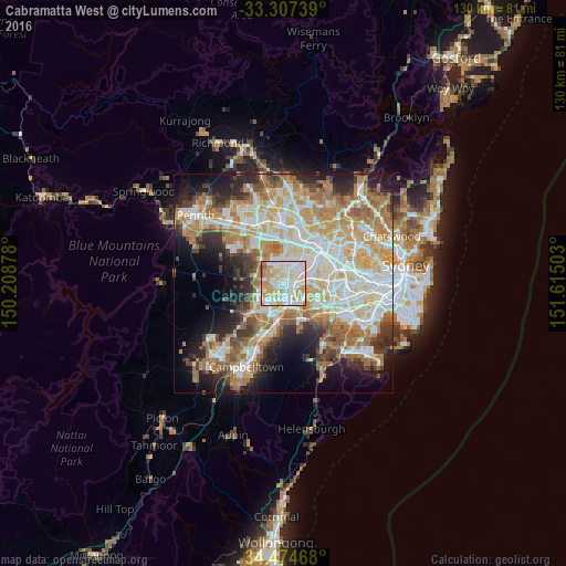
Analysis of Cabramatta West night lights 2016
Square area 10x10 km:
 29.37%
90-99
34.97%80-89
15.38%70-79
15.38%60-69
3.15%50-59
1.75%40-49
0%30-39
0%20-29
0%10-19
0%0-9
0%Square area 50x50 km:
11.84%90-99
13.38%80-89
7.47%70-79
9.3%60-69
10.26%50-59
5.47%40-49
3.89%30-39
5.36%20-29
6.92%10-19
9.59%0-9
16.51%Clear (daylight) street map image can be seen on geolist.org.
Map coordinates:
33° 18' 26.6" South, 150° 12' 31.6" East
33° 53' 34.9" South, 150° 54' 42.8" East
34° 28' 28.8" South, 151° 36' 54.1" East
Some cities around Cabramatta West sort by population:
• Liverpool
3.2 km =2 mi,  156°
156°
• Fairfield West
3 km =1.9 mi,  9°
9°
• Canley Heights
1.6 km =1 mi,  44°
44°
• Mount Pritchard
1.3 km =0.8 mi,  211°
211°
• Bonnyrigg
2.1 km =1.3 mi,  268°
268°
• St Johns Park
1.5 km =0.9 mi,  320°
320°
• Warwick Farm
3.2 km =2 mi,  133°
133°
• Greenfield Park
2.8 km =1.7 mi, 317°
9972621 (p: 7,138)
Sources (retrieved 2019-11-25):
» Earth at Night: Flat Maps 2012, 2016