Mount Pritchard night lights from space
Night Light of Mount Pritchard (New South Wales) from space (Australia) Src. Average luminocity for 10x10km area is 89.8042% and for 50x50km: 53.6632%.
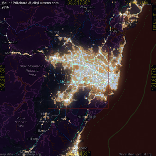
Analysis of Mount Pritchard night lights 2016
Square area 10x10 km:
 26.57%
90-99
34.44%80-89
16.78%70-79
15.38%60-69
4.02%50-59
2.8%40-49
0%30-39
0%20-29
0%10-19
0%0-9
0%Square area 50x50 km:
11.52%90-99
13.25%80-89
7.41%70-79
9.15%60-69
9.98%50-59
5.33%40-49
3.83%30-39
5.13%20-29
6.54%10-19
9.21%0-9
18.63%Clear (daylight) street map image can be seen on geolist.org.
Map coordinates:
33° 19' 2.6" South, 150° 12' 5.5" East
33° 54' 10.6" South, 150° 54' 16.7" East
34° 29' 4.3" South, 151° 36' 28" East
Some cities around Mount Pritchard sort by population:
• Liverpool
2.7 km =1.7 mi,  133°
133°
• Cabramatta
2.8 km =1.7 mi,  77°
77°
• Canley Heights
2.9 km =1.8 mi,  38°
38°
• Bonnyrigg
1.8 km =1.1 mi,  305°
305°
• Cabramatta West
1.3 km =0.8 mi,  31°
31°
• St Johns Park
2.2 km =1.4 mi,  353°
353°
• Warwick Farm
3.2 km =2 mi,  110°
110°
• Greenfield Park
3.4 km =2.1 mi,  339°
339°
8348692 (p: 9,926)
Sources (retrieved 2019-11-25):
» Earth at Night: Flat Maps 2012, 2016