Cabramatta night lights from space
Night Light of Cabramatta (New South Wales) from space (Australia) Src. Average luminocity for 10x10km area is 92.4825% and for 50x50km: 56.5922%.
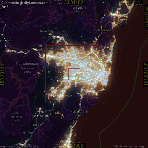

Analysis of Cabramatta night lights 2016
Square area 10x10 km:
 31.82%
90-99
35.49%80-89
18.53%70-79
13.64%60-69
0.17%50-59
0.35%40-49
0%30-39
0%20-29
0%10-19
0%0-9
0%Square area 50x50 km:
12.81%90-99
13.83%80-89
7.61%70-79
9.44%60-69
10.46%50-59
5.58%40-49
4.02%30-39
5.48%20-29
6.92%10-19
9.26%0-9
14.58%Clear (daylight) street map image can be seen on geolist.org.
Map coordinates:
33° 18' 42.6" South, 150° 13' 52.8" East
33° 53' 50.7" South, 150° 56' 4.1" East
34° 28' 44.6" South, 151° 38' 15.3" East
Some cities around Cabramatta sort by population:
• Liverpool
2.6 km =1.6 mi,  197°
197°
• Canley Heights
1.9 km =1.2 mi,  329°
329°
• Canley Vale
1.7 km =1.1 mi,  46°
46°
• Mount Pritchard
2.8 km =1.7 mi,  257°
257°
• Chipping Norton
3.2 km =2 mi,  134°
134°
• Fairfield Heights
3.7 km =2.3 mi,  6°
6°
• St Johns Park
3.4 km =2.1 mi,  298°
298°
• Warwick Farm
1.7 km =1.1 mi,  172°
172°
8348460 (p: 21,634)
Sources (retrieved 2019-11-25):
» Earth at Night: Flat Maps 2012, 2016