Canley Vale night lights from space
Night Light of Canley Vale (New South Wales) from space (Australia) Src. Average luminocity for 10x10km area is 93.9441% and for 50x50km: 57.9901%.
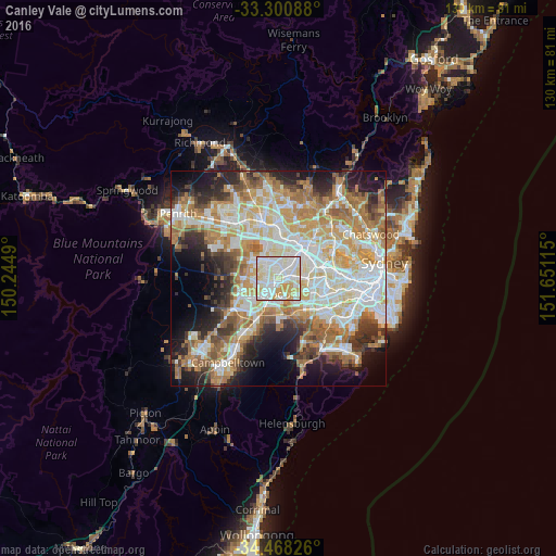
Analysis of Canley Vale night lights 2016
Square area 10x10 km:
 34.44%
90-99
39.69%80-89
16.43%70-79
9.44%60-69
0%50-59
0%40-49
0%30-39
0%20-29
0%10-19
0%0-9
0%Square area 50x50 km:
13.19%90-99
14.14%80-89
7.78%70-79
9.49%60-69
10.85%50-59
5.78%40-49
4%30-39
5.69%20-29
7.29%10-19
9.7%0-9
12.08%Clear (daylight) street map image can be seen on geolist.org.
Map coordinates:
33° 18' 3.2" South, 150° 14' 41.6" East
33° 53' 11.7" South, 150° 56' 52.9" East
34° 28' 5.7" South, 151° 39' 4.1" East
Some cities around Canley Vale sort by population:
• Cabramatta
1.7 km =1.1 mi,  226°
226°
• Fairfield
2.2 km =1.4 mi,  4°
4°
• Chipping Norton
3.6 km =2.2 mi,  163°
163°
• Fairfield Heights
2.6 km =1.6 mi,  340°
340°
• Cabramatta West
3.4 km =2.1 mi,  257°
257°
• Villawood
3 km =1.9 mi,  85°
85°
• Warwick Farm
3.1 km =1.9 mi,  199°
199°
• Fairfield East
2.9 km =1.8 mi,  48°
48°
8347759 (p: 10,162)
Sources (retrieved 2019-11-25):
» Earth at Night: Flat Maps 2012, 2016