Bruce night lights from space
Night Light of Bruce (ACT) from space (Australia) Src. Average luminocity for 10x10km area is 79.0752% and for 50x50km: 15.7292%.
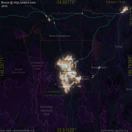
Analysis of Bruce night lights 2016
Square area 10x10 km:
100  17.66%
90-99 22.73%
80-89 10.84%
70-79 14.86%
60-69 19.93%
50-59 6.12%
40-49 2.97%
30-39 3.5%
20-29 1.4%
10-19 0%
0-9 0%
17.66%90-99
22.73%80-89
10.84%70-79
14.86%60-69
19.93%50-59
6.12%40-49
2.97%30-39
3.5%20-29
1.4%10-19
0%0-9
0%Square area 50x50 km:
100 2.46%
90-99 3.07%
80-89 1.54%
70-79 2.41%
60-69 3.81%
50-59 1.81%
40-49 1.38%
30-39 2.6%
20-29 3.38%
10-19 6.65%
0-9 70.9%
2.46%90-99
3.07%80-89
1.54%70-79
2.41%60-69
3.81%50-59
1.81%40-49
1.38%30-39
2.6%20-29
3.38%10-19
6.65%0-9
70.9%Clear (daylight) street map image can be seen on geolist.org.
Map coordinates:
34° 40' 4" South, 148° 23' 15.8" East
35° 14' 38.6" South, 149° 5' 27" East
35° 48' 58.5" South, 149° 47' 38.3" East
Some cities around Bruce sort by population:
• Kaleen
3.2 km =2 mi,  24°
24°
• Belconnen
2.3 km =1.4 mi,  286°
286°
• Braddon
5 km =3.1 mi,  126°
126°
• O'Connor
2.4 km =1.5 mi, 125°
• City
5.4 km =3.4 mi,  139°
139°
• Evatt
4.1 km =2.5 mi,  330°
330°
• Lyneham
3.7 km =2.3 mi,  82°
82°
• Ainslie
5.2 km =3.2 mi,  113°
113°
8349301 (p: 7,349)
Sources (retrieved 2019-11-25):
» Earth at Night: Flat Maps 2012, 2016