Lyneham night lights from space
Night Light of Lyneham (ACT) from space (Australia) Src. Average luminocity for 10x10km area is 68.9283% and for 50x50km: 15.7179%.
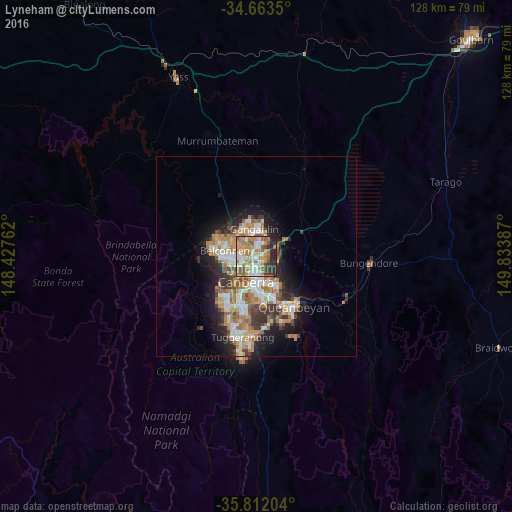
Analysis of Lyneham night lights 2016
Square area 10x10 km:
100  11.89%
90-99 15.73%
80-89 8.04%
70-79 13.29%
60-69 20.8%
50-59 8.92%
40-49 3.5%
30-39 7.52%
20-29 9.44%
10-19 0.87%
0-9 0%
11.89%90-99
15.73%80-89
8.04%70-79
13.29%60-69
20.8%50-59
8.92%40-49
3.5%30-39
7.52%20-29
9.44%10-19
0.87%0-9
0%Square area 50x50 km:
100 2.46%
90-99 3.06%
80-89 1.54%
70-79 2.4%
60-69 3.81%
50-59 1.84%
40-49 1.38%
30-39 2.62%
20-29 3.37%
10-19 6.61%
0-9 70.92%
2.46%90-99
3.06%80-89
1.54%70-79
2.4%60-69
3.81%50-59
1.84%40-49
1.38%30-39
2.62%20-29
3.37%10-19
6.61%0-9
70.92%Clear (daylight) street map image can be seen on geolist.org.
Map coordinates:
34° 39' 48.6" South, 148° 25' 39.4" East
35° 14' 23.3" South, 149° 7' 50.7" East
35° 48' 43.3" South, 149° 50' 1.9" East
Some cities around Lyneham sort by population:
• Bruce
3.7 km =2.3 mi,  262°
262°
• Kaleen
3.3 km =2.1 mi,  316°
316°
• Franklin
4.6 km =2.9 mi,  14°
14°
• Braddon
3.5 km =2.2 mi,  172°
172°
• Watson
2 km =1.2 mi,  84°
84°
• O'Connor
2.5 km =1.6 mi,  221°
221°
• City
4.6 km =2.9 mi,  181°
181°
• Ainslie
2.8 km =1.7 mi,  155°
155°
8347876 (p: 5,085)
Sources (retrieved 2019-11-25):
» Earth at Night: Flat Maps 2012, 2016