City night lights from space
Night Light of City (ACT) from space (Australia) Src. Average luminocity for 10x10km area is 76.778% and for 50x50km: 15.9886%.
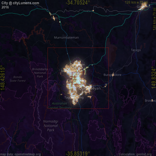
Analysis of City night lights 2016
Square area 10x10 km:
100  20.98%
90-99 22.38%
80-89 3.85%
70-79 10.66%
60-69 21.15%
50-59 6.82%
40-49 5.59%
30-39 5.42%
20-29 3.15%
10-19 0%
0-9 0%
20.98%90-99
22.38%80-89
3.85%70-79
10.66%60-69
21.15%50-59
6.82%40-49
5.59%30-39
5.42%20-29
3.15%10-19
0%0-9
0%Square area 50x50 km:
100 2.46%
90-99 3.09%
80-89 1.54%
70-79 2.43%
60-69 3.91%
50-59 1.84%
40-49 1.38%
30-39 2.62%
20-29 3.42%
10-19 7.12%
0-9 70.19%
2.46%90-99
3.09%80-89
1.54%70-79
2.43%60-69
3.91%50-59
1.84%40-49
1.38%30-39
2.62%20-29
3.42%10-19
7.12%0-9
70.19%Clear (daylight) street map image can be seen on geolist.org.
Map coordinates:
34° 42' 18.9" South, 148° 25' 34.1" East
35° 16' 52.5" South, 149° 7' 45.4" East
35° 51' 11.5" South, 149° 49' 56.6" East
Some cities around City sort by population:
• Canberra
0.3 km =0.2 mi,  203°
203°
• Bruce
5.4 km =3.4 mi,  319°
319°
• Braddon
1.3 km =0.8 mi,  26°
26°
• Watson
5.2 km =3.2 mi,  23°
23°
• O'Connor
3.2 km =2 mi,  331°
331°
• Lyneham
4.6 km =2.9 mi,  1°
1°
• Ainslie
2.5 km =1.6 mi, 32°
• Campbell
2.4 km =1.5 mi,  111°
111°
8347868 (p: 5,417)
Sources (retrieved 2019-11-25):
» Earth at Night: Flat Maps 2012, 2016