Braddon night lights from space
Night Light of Braddon (ACT) from space (Australia) Src. Average luminocity for 10x10km area is 73.8147% and for 50x50km: 15.9757%.
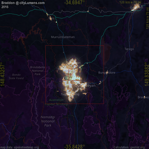
Analysis of Braddon night lights 2016
Square area 10x10 km:
100  18.88%
90-99 19.58%
80-89 5.94%
70-79 11.01%
60-69 20.1%
50-59 5.94%
40-49 4.9%
30-39 6.29%
20-29 7.34%
10-19 0%
0-9 0%
18.88%90-99
19.58%80-89
5.94%70-79
11.01%60-69
20.1%50-59
5.94%40-49
4.9%30-39
6.29%20-29
7.34%10-19
0%0-9
0%Square area 50x50 km:
100 2.46%
90-99 3.09%
80-89 1.54%
70-79 2.43%
60-69 3.91%
50-59 1.84%
40-49 1.38%
30-39 2.62%
20-29 3.42%
10-19 7.12%
0-9 70.19%
2.46%90-99
3.09%80-89
1.54%70-79
2.43%60-69
3.91%50-59
1.84%40-49
1.38%30-39
2.62%20-29
3.42%10-19
7.12%0-9
70.19%Clear (daylight) street map image can be seen on geolist.org.
Map coordinates:
34° 41' 40.9" South, 148° 25' 57.3" East
35° 16' 14.8" South, 149° 8' 8.5" East
35° 50' 34.1" South, 149° 50' 19.8" East
Some cities around Braddon sort by population:
• Canberra
1.6 km =1 mi,  206°
206°
• Bruce
5 km =3.1 mi,  306°
306°
• Watson
3.9 km =2.4 mi,  23°
23°
• O'Connor
2.6 km =1.6 mi, 307°
• City
1.3 km =0.8 mi, 206°
• Lyneham
3.5 km =2.2 mi,  352°
352°
• Ainslie
1.2 km =0.7 mi,  38°
38°
• Campbell
2.6 km =1.6 mi,  141°
141°
8349165 (p: 6,238)
Sources (retrieved 2019-11-25):
» Earth at Night: Flat Maps 2012, 2016