Belconnen night lights from space
Night Light of Belconnen (ACT) from space (Australia) Src. Average luminocity for 10x10km area is 72.1031% and for 50x50km: 15.6641%.
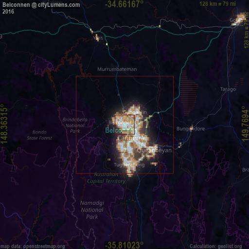
Analysis of Belconnen night lights 2016
Square area 10x10 km:
100  13.29%
90-99 16.43%
80-89 11.19%
70-79 14.86%
60-69 21.5%
50-59 6.64%
40-49 3.15%
30-39 3.15%
20-29 8.22%
10-19 1.57%
0-9 0%
13.29%90-99
16.43%80-89
11.19%70-79
14.86%60-69
21.5%50-59
6.64%40-49
3.15%30-39
3.15%20-29
8.22%10-19
1.57%0-9
0%Square area 50x50 km:
100 2.46%
90-99 3.06%
80-89 1.54%
70-79 2.4%
60-69 3.78%
50-59 1.81%
40-49 1.38%
30-39 2.59%
20-29 3.37%
10-19 6.56%
0-9 71.06%
2.46%90-99
3.06%80-89
1.54%70-79
2.4%60-69
3.78%50-59
1.81%40-49
1.38%30-39
2.59%20-29
3.37%10-19
6.56%0-9
71.06%Clear (daylight) street map image can be seen on geolist.org.
Map coordinates:
34° 39' 42" South, 148° 21' 47.3" East
35° 14' 16.7" South, 149° 3' 58.6" East
35° 48' 36.8" South, 149° 46' 9.8" East
Some cities around Belconnen sort by population:
• Bruce
2.3 km =1.4 mi,  106°
106°
• Kaleen
4.2 km =2.6 mi,  58°
58°
• Dunlop
6.5 km =4 mi,  319°
319°
• Nicholls
6.3 km =3.9 mi,  25°
25°
• Macgregor
5.9 km =3.7 mi,  301°
301°
• O'Connor
4.7 km =2.9 mi,  116°
116°
• Evatt
2.9 km =1.8 mi,  4°
4°
• Lyneham
5.9 km =3.7 mi,  91°
91°
2176373 (p: 6,621)
Sources (retrieved 2019-11-25):
» Earth at Night: Flat Maps 2012, 2016