Surrey Hills night lights from space
Night Light of Surrey Hills (Victoria) from space (Australia) Src. Average luminocity for 10x10km area is 83.9337% and for 50x50km: 52.4161%.
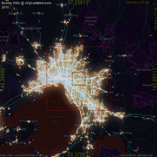
Analysis of Surrey Hills night lights 2016
Square area 10x10 km:
 14.63%
90-99
25.68%80-89
18.54%70-79
27.89%60-69
10.37%50-59
2.89%40-49
0%30-39
0%20-29
0%10-19
0%0-9
0%Square area 50x50 km:
13.63%90-99
12.77%80-89
6.34%70-79
9.36%60-69
7.99%50-59
5.62%40-49
3.91%30-39
3.64%20-29
5.83%10-19
7.37%0-9
23.54%Clear (daylight) street map image can be seen on geolist.org.
Map coordinates:
37° 15' 32.9" South, 144° 23' 48.8" East
37° 49' 0" South, 145° 6' 0" East
38° 22' 12.1" South, 145° 48' 11.3" East
Some cities around Surrey Hills sort by population:
• Doncaster
3.8 km =2.4 mi,  33°
33°
• Balwyn North
2.9 km =1.8 mi,  349°
349°
• Balwyn
2 km =1.2 mi,  294°
294°
• Box Hill
2.2 km =1.4 mi,  96°
96°
• Box Hill North
2.8 km =1.7 mi,  56°
56°
• Box Hill South
2.5 km =1.6 mi,  133°
133°
• Canterbury
1.6 km =1 mi,  236°
236°
• Mont Albert North
1.9 km =1.2 mi,  21°
21°
2147826 (p: 13,268)
Sources (retrieved 2019-11-25):
» Earth at Night: Flat Maps 2012, 2016