Toongabbie night lights from space
Night Light of Toongabbie (New South Wales) from space (Australia) Src. Average luminocity for 10x10km area is 90.6978% and for 50x50km: 52.0306%.
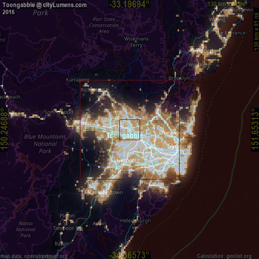
Analysis of Toongabbie night lights 2016
Square area 10x10 km:
 27.84%
90-99
34.43%80-89
19.6%70-79
14.47%60-69
2.93%50-59
0.73%40-49
0%30-39
0%20-29
0%10-19
0%0-9
0%Square area 50x50 km:
12.17%90-99
13.22%80-89
7.21%70-79
8.74%60-69
8.86%50-59
4.43%40-49
3.35%30-39
4.88%20-29
6.16%10-19
7.88%0-9
23.11%Clear (daylight) street map image can be seen on geolist.org.
Map coordinates:
33° 11' 49" South, 150° 14' 48.8" East
33° 46' 60" South, 150° 57' 0" East
34° 21' 56.6" South, 151° 39' 11.3" East
Some cities around Toongabbie sort by population:
• Blacktown
3.6 km =2.2 mi,  301°
301°
• Seven Hills
1.5 km =0.9 mi,  270°
270°
• Winston Hills
2.9 km =1.8 mi,  74°
74°
• Wentworthville
3.1 km =1.9 mi,  147°
147°
• Kings Langley
3.9 km =2.4 mi,  339°
339°
• Lalor Park
3 km =1.9 mi,  325°
325°
• Pendle Hill
2.4 km =1.5 mi,  167°
167°
• Girraween
1.9 km =1.2 mi,  200°
200°
2146305 (p: 14,218)
Sources (retrieved 2019-11-25):
» Earth at Night: Flat Maps 2012, 2016