Elizabeth Bay night lights from space
Night Light of Elizabeth Bay (New South Wales) from space (Australia) Src. Average luminocity for 10x10km area is 84.5035% and for 50x50km: 38.9253%.
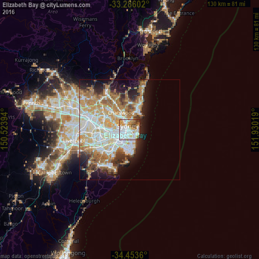
Analysis of Elizabeth Bay night lights 2016
Square area 10x10 km:
 36.71%
90-99
22.9%80-89
4.55%70-79
13.11%60-69
8.92%50-59
4.2%40-49
4.72%30-39
3.85%20-29
1.05%10-19
0%0-9
0%Square area 50x50 km:
9.04%90-99
9.64%80-89
4.7%70-79
6.37%60-69
7.59%50-59
3.57%40-49
2.42%30-39
3.48%20-29
4.72%10-19
8.38%0-9
40.09%Clear (daylight) street map image can be seen on geolist.org.
Map coordinates:
33° 17' 9.7" South, 150° 31' 26.2" East
33° 52' 18.5" South, 151° 13' 37.4" East
34° 27' 13" South, 151° 55' 48.7" East
Some cities around Elizabeth Bay sort by population:
• Sydney
1.9 km =1.2 mi,  283°
283°
• Sydney Central Business District
1.9 km =1.2 mi,  293°
293°
• Surry Hills
1.9 km =1.2 mi,  224°
224°
• Paddington
1.4 km =0.9 mi,  163°
163°
• Potts Point
0.5 km =0.3 mi,  348°
348°
• Darlinghurst
1.1 km =0.7 mi, 220°
• Haymarket
2.2 km =1.4 mi,  249°
249°
• Woollahra
2 km =1.2 mi,  153°
153°
8348543 (p: 5,270)
Sources (retrieved 2019-11-25):
» Earth at Night: Flat Maps 2012, 2016