Aubin Grove night lights from space
Night Light of Aubin Grove (Western Australia) from space (Australia) Src. Average luminocity for 10x10km area is 48.7955% and for 50x50km: 32.0981%.
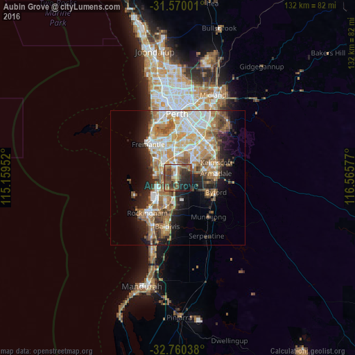
Analysis of Aubin Grove night lights 2016
Square area 10x10 km:
 4.55%
4.55%90-99
4.02%80-89
4.37%70-79
5.42%60-69
15.73%50-59
11.54%40-49
14.51%30-39
12.24%20-29
14.34%10-19
12.41%0-9
0.87%Square area 50x50 km:
5.97%90-99
6.45%80-89
3.69%70-79
4.43%60-69
7.23%50-59
5.1%40-49
3.62%30-39
3.39%20-29
5.56%10-19
8.74%0-9
45.82%Clear (daylight) street map image can be seen on geolist.org.
Map coordinates:
31° 34' 12" South, 115° 9' 34.3" East
32° 10' 1.7" South, 115° 51' 45.5" East
32° 45' 37.4" South, 116° 33' 56.8" East
Some cities around Aubin Grove sort by population:
• Success
3 km =1.9 mi,  336°
336°
• Atwell
2.6 km =1.6 mi,  5°
5°
• Piara Waters
6.3 km =3.9 mi,  53°
53°
• Yangebup
6.8 km =4.2 mi,  319°
319°
• Beeliar
6.5 km =4 mi,  305°
305°
• Bertram
8.7 km =5.4 mi,  190°
190°
• South Lake
6.6 km =4.1 mi, 340°
• Bibra Lake
8.7 km =5.4 mi,  332°
332°
8348783 (p: 6,183)
Sources (retrieved 2019-11-25):
» Earth at Night: Flat Maps 2012, 2016