Mīr Bachah Kōṯ night lights from space
Night Light of Mīr Bachah Kōṯ (Kabul) from space (Afghanistan) Src. Average luminocity for 10x10km area is 1.989% and for 50x50km: 12.0668%.
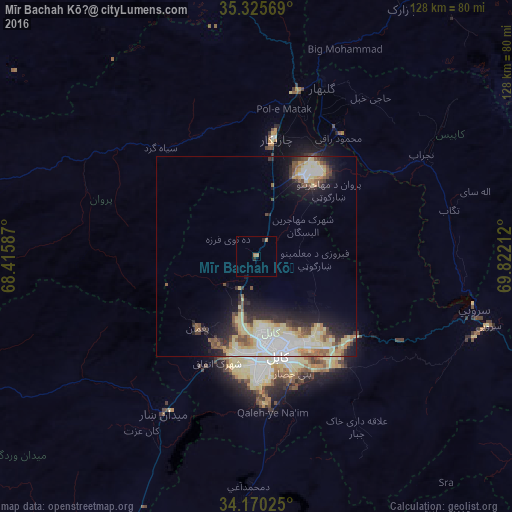
Analysis of Mīr Bachah Kōṯ night lights 2016
Square area 10x10 km:
 0%
0%90-99
0%80-89
0%70-79
0%60-69
2.2%50-59
0%40-49
0%30-39
0.73%20-29
0.73%10-19
0%0-9
96.34%Square area 50x50 km:
2.53%90-99
1.84%80-89
2.95%70-79
1.1%60-69
1.16%50-59
1.4%40-49
1.39%30-39
1.38%20-29
2.62%10-19
5.18%0-9
78.46%Clear (daylight) street map image can be seen on geolist.org.
Map coordinates:
35° 19' 32.5" North, 68° 24' 57.1" East
34° 44' 60" North, 69° 7' 8.4" East
34° 10' 12.9" North, 69° 49' 19.6" East
Some cities around Mīr Bachah Kōṯ sort by population:
• Kabul
25.1 km =15.6 mi,  168°
168°
• Bāzārak
72.2 km =44.9 mi,  29°
29°
• Charikar
29.7 km =18.5 mi,  9°
9°
• Paghmān
23.7 km =14.7 mi,  220°
220°
• Jabal os Saraj
42.4 km =26.3 mi, 14°
• Sidqābād
37 km =23 mi, 34°
• Tagāb
49.8 km =30.9 mi,  76°
76°
• Maydanshakhr
45.7 km =28.4 mi,  210°
210°
1133270 (p: 5,405)
Sources (retrieved 2019-11-25):
» Earth at Night: Flat Maps 2012, 2016