Wesselsbron night lights from space
Night Light of Wesselsbron (Orange Free State) from space (South Africa) Src. Average luminocity for 10x10km area is 8.6458% and for 50x50km: 0.4068%.

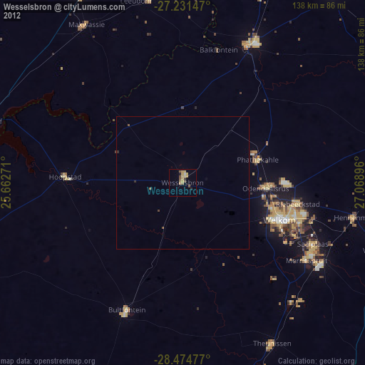
Analysis of Wesselsbron night lights 2016
Square area 10x10 km:
 0%
0%90-99
0%80-89
0%70-79
5.3%60-69
1.89%50-59
1.14%40-49
1.14%30-39
1.89%20-29
0.76%10-19
0.76%0-9
87.12%Square area 50x50 km:
0%90-99
0%80-89
0%70-79
0.21%60-69
0.08%50-59
0.05%40-49
0.05%30-39
0.14%20-29
0.03%10-19
0.03%0-9
99.42%Clear (daylight) street map image can be seen on geolist.org.
Map coordinates:
27° 13' 53.3" South, 25° 39' 45.8" East
27° 51' 17.6" South, 26° 21' 57" East
28° 28' 29.2" South, 27° 4' 8.3" East
Some cities around Wesselsbron sort by population:
• Welkom
38.8 km =24.1 mi,  110°
110°
• Virginia
56.4 km =35 mi,  119°
119°
• Kutloanong
37.8 km =23.5 mi,  86°
86°
• Bothaville
57.4 km =35.7 mi,  25°
25°
• Theunissen
70 km =43.5 mi,  152°
152°
• Allanridge
29.5 km =18.3 mi,  67°
67°
• Hennenman
66.1 km =41.1 mi,  101°
101°
• Hoopstad
45 km =28 mi,  273°
273°
940424 (p: 42,552)
Sources (retrieved 2019-11-25):
» Earth at Night: Flat Maps 2012, 2016