Koster night lights from space
Night Light of Koster (North-West) from space (South Africa) Src. Average luminocity for 10x10km area is 8.7557% and for 50x50km: 0.9819%.
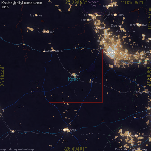
Analysis of Koster night lights 2016
Square area 10x10 km:
 0%
0%90-99
0%80-89
2.27%70-79
2.46%60-69
2.27%50-59
0.76%40-49
1.89%30-39
0.95%20-29
1.52%10-19
0%0-9
87.88%Square area 50x50 km:
0%90-99
0%80-89
0.13%70-79
0.16%60-69
0.17%50-59
0.19%40-49
0.27%30-39
0.26%20-29
0.36%10-19
0.39%0-9
98.06%Clear (daylight) street map image can be seen on geolist.org.
Map coordinates:
25° 13' 43.1" South, 26° 11' 40" East
25° 51' 46.8" South, 26° 53' 51.2" East
26° 29' 38.4" South, 27° 36' 2.5" East
Some cities around Koster sort by population:
• Krugersdorp
91.2 km =56.7 mi,  105°
105°
• Carletonville
74.6 km =46.4 mi,  137°
137°
• Westonaria
90.5 km =56.2 mi,  124°
124°
• Randfontein
88 km =54.7 mi, 113°
• Rustenburg
40.8 km =25.4 mi,  57°
57°
• Lichtenburg
80.4 km =50 mi,  246°
246°
• Zeerust
90 km =55.9 mi,  293°
293°
• Maile
60.6 km =37.7 mi,  39°
39°
987648 (p: 12,126)
Sources (retrieved 2019-11-25):
» Earth at Night: Flat Maps 2012, 2016