Ballito night lights from space
Night Light of Ballito (KwaZulu-Natal) from space (South Africa) Src. Average luminocity for 10x10km area is 27.6648% and for 50x50km: 13.9786%.
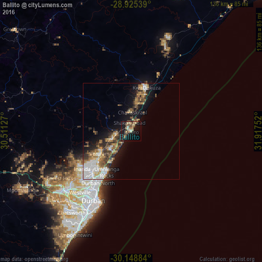
Analysis of Ballito night lights 2016
Square area 10x10 km:
 0.38%
0.38%90-99
3.22%80-89
7.01%70-79
3.22%60-69
4.55%50-59
2.65%40-49
6.82%30-39
3.22%20-29
2.84%10-19
38.45%0-9
27.65%Square area 50x50 km:
2.32%90-99
2.49%80-89
1.7%70-79
1.84%60-69
1.83%50-59
1.93%40-49
2.17%30-39
2.36%20-29
2.5%10-19
9%0-9
71.85%Clear (daylight) street map image can be seen on geolist.org.
Map coordinates:
28° 55' 31.4" South, 30° 30' 40.6" East
29° 32' 20.3" South, 31° 12' 51.8" East
30° 8' 55.8" South, 31° 55' 3.1" East
Some cities around Ballito sort by population:
• Durban
39.7 km =24.7 mi,  206°
206°
• Pietermaritzburg
79.9 km =49.6 mi,  263°
263°
• Mpumalanga
63.6 km =39.5 mi,  241°
241°
• KwaDukuza
24.5 km =15.2 mi,  17°
17°
• Berea
40.8 km =25.4 mi, 211°
• Eshowe
76.7 km =47.7 mi, 18°
• Greytown
80.1 km =49.8 mi,  311°
311°
• Sundumbili
48.4 km =30.1 mi, 21°
1021360 (p: 17,218)
Sources (retrieved 2019-11-25):
» Earth at Night: Flat Maps 2012, 2016