Berea night lights from space
Night Light of Berea (KwaZulu-Natal) from space (South Africa) Src. Average luminocity for 10x10km area is 97.744% and for 50x50km: 37.6718%.
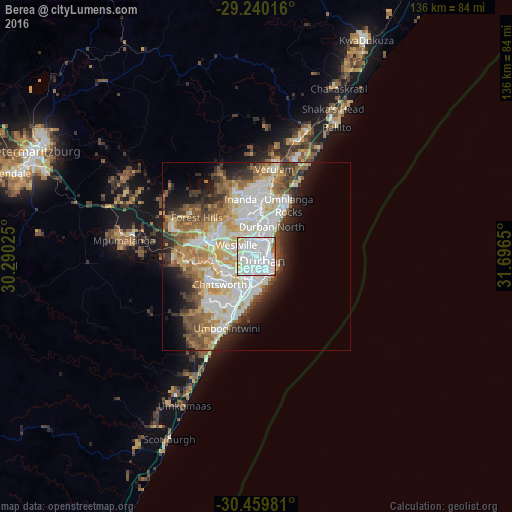
Analysis of Berea night lights 2016
Square area 10x10 km:
 68.65%
90-99
24.6%80-89
4.17%70-79
0.2%60-69
1.59%50-59
0.79%40-49
0%30-39
0%20-29
0%10-19
0%0-9
0%Square area 50x50 km:
10.47%90-99
8.33%80-89
4.88%70-79
4.73%60-69
4.29%50-59
4.75%40-49
4.05%30-39
4.2%20-29
5.34%10-19
7.59%0-9
41.37%Clear (daylight) street map image can be seen on geolist.org.
Map coordinates:
29° 14' 24.6" South, 30° 17' 24.9" East
29° 51' 6.7" South, 30° 59' 36.1" East
30° 27' 35.3" South, 31° 41' 47.4" East
Some cities around Berea sort by population:
• Durban
3.5 km =2.2 mi,  101°
101°
• Pietermaritzburg
63.6 km =39.5 mi,  294°
294°
• Mpumalanga
34.7 km =21.6 mi,  277°
277°
• KwaDukuza
64.9 km =40.3 mi,  26°
26°
• Richmond
69.6 km =43.2 mi,  268°
268°
• Scottburgh
53.6 km =33.3 mi,  205°
205°
• eMkhomazi
43.7 km =27.2 mi, 205°
• Ballito
40.8 km =25.4 mi, 31°
1020066 (p: 15,000)
Sources (retrieved 2019-11-25):
» Earth at Night: Flat Maps 2012, 2016