Laḩij night lights from space
Night Light of Laḩij from space (Yemen) Src. Average luminocity for 10x10km area is 8.9026% and for 50x50km: 5.0419%.

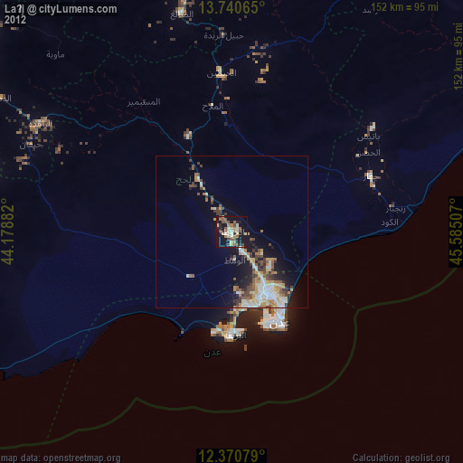
Analysis of Laḩij night lights 2016
Square area 10x10 km:
 0%
0%90-99
0%80-89
0.65%70-79
0.22%60-69
0%50-59
3.46%40-49
1.52%30-39
8.23%20-29
1.73%10-19
4.11%0-9
80.09%Square area 50x50 km:
0.39%90-99
0.42%80-89
0.38%70-79
0.91%60-69
0.77%50-59
0.73%40-49
1.38%30-39
1.49%20-29
1.51%10-19
3.37%0-9
88.65%Clear (daylight) street map image can be seen on geolist.org.
Map coordinates:
13° 44' 26.3" North, 44° 10' 43.8" East
13° 3' 24" North, 44° 52' 55" East
12° 22' 14.8" North, 45° 35' 6.3" East
Some cities around Laḩij sort by population:
• Ta‘izz
109.8 km =68.2 mi,  301°
301°
• Aden
35.1 km =21.8 mi,  151°
151°
• Ibb
126.3 km =78.5 mi,  323°
323°
• Dhī as Sufāl
119.8 km =74.4 mi, 316°
• Al Bayda
127.4 km =79.2 mi,  35°
35°
• Zinjibār
54.6 km =33.9 mi,  81°
81°
• Dhalie
72.9 km =45.3 mi,  347°
347°
• Jawf al Maqbābah
134.8 km =83.8 mi,  49°
49°
73560 (p: 23,375)
Sources (retrieved 2019-11-25):
» Earth at Night: Flat Maps 2012, 2016