Jadder Cemetery night lights from space
Night Light of Jadder Cemetery (Amanat Al Asimah) from space (Yemen) Src. Average luminocity for 10x10km area is 3.1126% and for 50x50km: 2.5254%.
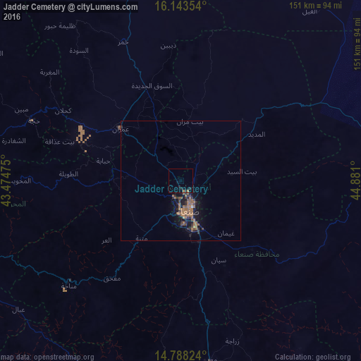
Analysis of Jadder Cemetery night lights 2016
Square area 10x10 km:
 0%
0%90-99
0%80-89
0%70-79
0%60-69
1.73%50-59
0%40-49
0%30-39
0%20-29
3.46%10-19
0.87%0-9
93.94%Square area 50x50 km:
0.03%90-99
0.01%80-89
0.07%70-79
0%60-69
1.54%50-59
0.55%40-49
0.33%30-39
0.56%20-29
0.8%10-19
2.28%0-9
93.84%Clear (daylight) street map image can be seen on geolist.org.
Map coordinates:
16° 8' 36.7" North, 43° 28' 29.1" East
15° 28' 1.2" North, 44° 10' 40.3" East
14° 47' 17.7" North, 44° 52' 51.6" East
Some cities around Jadder Cemetery sort by population:
• Sanaa
12.9 km =8 mi,  166°
166°
• ‘Amrān
33 km =20.5 mi,  310°
310°
• Sayyān
36.4 km =22.6 mi,  154°
154°
• Ḩajjah
66.3 km =41.2 mi,  292°
292°
• Saḩar
21.9 km =13.6 mi,  140°
140°
• Al Ḩazm
100.6 km =62.5 mi,  39°
39°
• Al Maḩwīt
67.8 km =42.1 mi,  270°
270°
• Al Jabīn
105.2 km =65.4 mi,  216°
216°
11776817 (p: 10,000)
Sources (retrieved 2019-11-25):
» Earth at Night: Flat Maps 2012, 2016