Ðông Hà night lights from space
Night Light of Ðông Hà (Quảng Trị) from space (Vietnam) Src. Average luminocity for 10x10km area is 34.5043% and for 50x50km: 1.8781%.
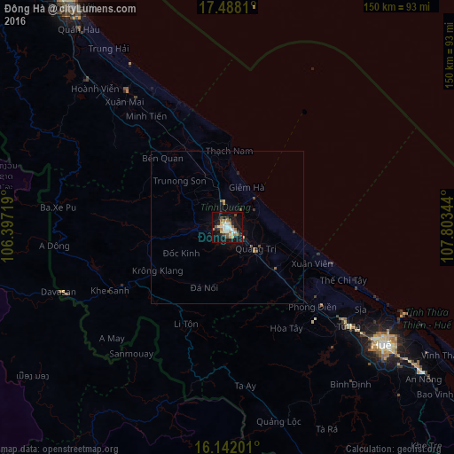
Analysis of Ðông Hà night lights 2016
Square area 10x10 km:
 3.46%
3.46%90-99
10.39%80-89
2.38%70-79
2.6%60-69
7.14%50-59
3.46%40-49
4.98%30-39
2.16%20-29
5.41%10-19
40.26%0-9
17.75%Square area 50x50 km:
0.13%90-99
0.4%80-89
0.13%70-79
0.14%60-69
0.36%50-59
0.28%40-49
0.29%30-39
0.15%20-29
0.25%10-19
1.8%0-9
96.07%Clear (daylight) street map image can be seen on geolist.org.
Map coordinates:
17° 29' 17.2" North, 106° 23' 49.9" East
16° 48' 58.5" North, 107° 6' 1.1" East
16° 8' 31.2" North, 107° 48' 12.4" East
Some cities around Ðông Hà sort by population:
• Da Nang
145.6 km =90.5 mi,  124°
124°
• Huế
65.8 km =40.9 mi,  126°
126°
• Tam Kỳ
201.5 km =125.2 mi, 133°
• Hội An
167.9 km =104.3 mi, 128°
• Kwang Binh
88.6 km =55.1 mi,  325°
325°
• Hà Tĩnh
211.8 km =131.6 mi,  323°
323°
• Salavan, LA
142.4 km =88.5 mi,  210°
210°
• Sekong, LA
168.4 km =104.6 mi,  193°
193°
1582926 (p: 17,662)
Sources (retrieved 2019-11-25):
» Earth at Night: Flat Maps 2012, 2016