Tarariras night lights from space
Night Light of Tarariras (Colonia) from space (Uruguay) Src. Average luminocity for 10x10km area is 4.13% and for 50x50km: 1.6046%.
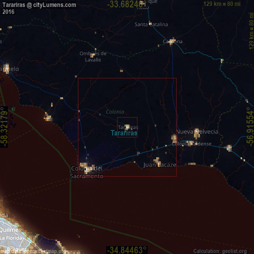
Analysis of Tarariras night lights 2016
Square area 10x10 km:
 0%
0%90-99
0%80-89
0.73%70-79
0.73%60-69
1.47%50-59
0.73%40-49
1.47%30-39
0.73%20-29
0.73%10-19
0%0-9
93.41%Square area 50x50 km:
0.01%90-99
0.05%80-89
0.26%70-79
0.15%60-69
0.49%50-59
0.54%40-49
0.22%30-39
0.49%20-29
0.22%10-19
0.25%0-9
97.33%Clear (daylight) street map image can be seen on geolist.org.
Map coordinates:
33° 40' 56.9" South, 58° 19' 18.4" West
34° 15' 56" South, 57° 37' 7.2" West
34° 50' 40.7" South, 56° 54' 55.9" West
Some cities around Tarariras sort by population:
• Quilmes, AR
78.4 km =48.7 mi,  228°
228°
• Berazategui, AR
77.8 km =48.3 mi,  224°
224°
• Retiro, AR
78.5 km =48.8 mi,  243°
243°
• Colonia del Sacramento
29.9 km =18.6 mi, 222°
• Carmelo
68 km =42.3 mi,  295°
295°
• Juan L. Lacaze
22.9 km =14.2 mi,  138°
138°
• Nueva Helvecia
35.6 km =22.1 mi,  96°
96°
• Rosario
25.3 km =15.7 mi, 102°
3439902 (p: 6,069)
Sources (retrieved 2019-11-25):
» Earth at Night: Flat Maps 2012, 2016