Yarmouth night lights from space
Night Light of Yarmouth (Maine) from space (United States) Src. Average luminocity for 10x10km area is 12.2212% and for 50x50km: 9.9381%.
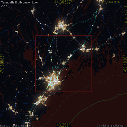
Analysis of Yarmouth night lights 2016
Square area 10x10 km:
 0%
0%90-99
0%80-89
2.58%70-79
2.12%60-69
3.03%50-59
3.03%40-49
0.45%30-39
0.76%20-29
1.97%10-19
1.21%0-9
84.85%Square area 50x50 km:
1.27%90-99
1.96%80-89
1.26%70-79
1.01%60-69
1.44%50-59
1.2%40-49
1.23%30-39
1.27%20-29
2.61%10-19
5.28%0-9
81.47%Clear (daylight) street map image can be seen on geolist.org.
Map coordinates:
44° 18' 21.5" North, 70° 53' 23.5" West
43° 48' 2.3" North, 70° 11' 12.2" West
43° 17' 27.6" North, 69° 29' 1" West
Some cities around Yarmouth sort by population:
• Portland
17 km =10.6 mi,  200°
200°
• South Portland
18.2 km =11.3 mi,  193°
193°
• South Portland Gardens
20.7 km =12.9 mi,  209°
209°
• Westbrook
20.2 km =12.6 mi,  227°
227°
• Brunswick
21.8 km =13.5 mi,  54°
54°
• Topsham
22 km =13.7 mi, 50°
• New Gloucester
19.6 km =12.2 mi,  336°
336°
• Harpswell Center
16.3 km =10.1 mi,  89°
89°
4983572 (p: 5,869)
Sources (retrieved 2019-11-25):
» Earth at Night: Flat Maps 2012, 2016