Woods Cross night lights from space
Night Light of Woods Cross (Utah) from space (United States) Src. Average luminocity for 10x10km area is 62.8503% and for 50x50km: 23.6073%.
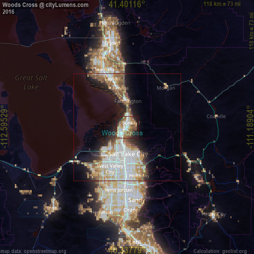
Analysis of Woods Cross night lights 2016
Square area 10x10 km:
 11.39%
90-99
14.46%80-89
6.97%70-79
10.88%60-69
14.46%50-59
9.86%40-49
5.78%30-39
5.61%20-29
12.24%10-19
8.33%0-9
0%Square area 50x50 km:
6.19%90-99
5.59%80-89
2.62%70-79
2.61%60-69
3.14%50-59
3.07%40-49
1.95%30-39
1.76%20-29
4.25%10-19
7.71%0-9
61.1%Clear (daylight) street map image can be seen on geolist.org.
Map coordinates:
41° 24' 4.2" North, 112° 35' 43" West
40° 52' 17.8" North, 111° 53' 31.8" West
40° 20' 16" North, 111° 11' 20.5" West
Some cities around Woods Cross sort by population:
• Salt Lake City
12.3 km =7.6 mi,  179°
179°
• Bountiful
2.2 km =1.4 mi,  25°
25°
• South Salt Lake
17 km =10.6 mi, 178°
• Farmington
12.1 km =7.5 mi,  1°
1°
• North Salt Lake
2.8 km =1.7 mi,  205°
205°
• Centerville
5.4 km =3.4 mi,  18°
18°
• Fruit Heights
17.9 km =11.1 mi,  357°
357°
• West Bountiful
2.6 km =1.6 mi,  341°
341°
5785116 (p: 11,284)
Sources (retrieved 2019-11-25):
» Earth at Night: Flat Maps 2012, 2016