Winston night lights from space
Night Light of Winston (Florida) from space (United States) Src. Average luminocity for 10x10km area is 81.5246% and for 50x50km: 44.1129%.
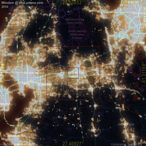
Analysis of Winston night lights 2016
Square area 10x10 km:
 20.83%
90-99
24.62%80-89
7.95%70-79
17.05%60-69
18.37%50-59
6.82%40-49
2.84%30-39
1.14%20-29
0.38%10-19
0%0-9
0%Square area 50x50 km:
4.51%90-99
5.91%80-89
3.42%70-79
5.18%60-69
18.18%50-59
8.96%40-49
7.84%30-39
7.14%20-29
8.3%10-19
12.64%0-9
17.93%Clear (daylight) street map image can be seen on geolist.org.
Map coordinates:
28° 39' 1.9" North, 82° 43' 4.6" West
28° 1' 54.1" North, 82° 0' 53.3" West
27° 24' 33.4" North, 81° 18' 42.1" West
Some cities around Winston sort by population:
• Lakeland
6.4 km =4 mi,  82°
82°
• Plant City
9.9 km =6.2 mi,  261°
261°
• Lakeland Highlands
10.2 km =6.3 mi,  141°
141°
• Medulla
8.2 km =5.1 mi,  150°
150°
• Willow Oak
12.9 km =8 mi,  181°
181°
• Kathleen
9.9 km =6.2 mi,  355°
355°
• Combee Settlement
11.1 km =6.9 mi,  74°
74°
• Crystal Lake
10.5 km =6.5 mi,  87°
87°
4178540 (p: 9,050)
Sources (retrieved 2019-11-25):
» Earth at Night: Flat Maps 2012, 2016