Lakeland Highlands night lights from space
Night Light of Lakeland Highlands (Florida) from space (United States) Src. Average luminocity for 10x10km area is 76.9432% and for 50x50km: 39.9075%.
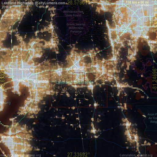
Analysis of Lakeland Highlands night lights 2016
Square area 10x10 km:
 14.39%
90-99
16.67%80-89
17.42%70-79
18.75%60-69
16.67%50-59
5.11%40-49
6.06%30-39
4.92%20-29
0%10-19
0%0-9
0%Square area 50x50 km:
4.49%90-99
5.41%80-89
2.75%70-79
4.68%60-69
15.87%50-59
8.67%40-49
6.99%30-39
6.34%20-29
7.37%10-19
10.51%0-9
26.93%Clear (daylight) street map image can be seen on geolist.org.
Map coordinates:
28° 34' 44.4" North, 82° 39' 11.6" West
27° 57' 35.1" North, 81° 57' 0.3" West
27° 20' 12.9" North, 81° 14' 49.1" West
Some cities around Lakeland Highlands sort by population:
• Bartow
12.6 km =7.8 mi,  123°
123°
• Highland City
7.1 km =4.4 mi,  85°
85°
• Winston
10.2 km =6.3 mi,  321°
321°
• Medulla
2.5 km =1.6 mi,  291°
291°
• Fuller Heights
7.3 km =4.5 mi,  220°
220°
• Willow Oak
8.2 km =5.1 mi,  233°
233°
• Combee Settlement
11.8 km =7.3 mi,  21°
21°
• Crystal Lake
9.4 km =5.8 mi,  25°
25°
4161444 (p: 11,056)
Sources (retrieved 2019-11-25):
» Earth at Night: Flat Maps 2012, 2016