Crystal Lake night lights from space
Night Light of Crystal Lake (Florida) from space (United States) Src. Average luminocity for 10x10km area is 80.2614% and for 50x50km: 41.0687%.
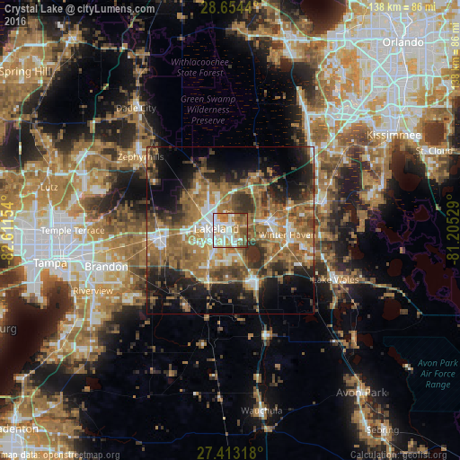
Analysis of Crystal Lake night lights 2016
Square area 10x10 km:
 21.21%
90-99
22.92%80-89
9.66%70-79
8.52%60-69
22.73%50-59
10.61%40-49
4.36%30-39
0%20-29
0%10-19
0%0-9
0%Square area 50x50 km:
4.61%90-99
5.61%80-89
2.88%70-79
4.85%60-69
16.05%50-59
8.25%40-49
6.83%30-39
6.85%20-29
8.4%10-19
12.81%0-9
22.84%Clear (daylight) street map image can be seen on geolist.org.
Map coordinates:
28° 39' 15.8" North, 82° 36' 41.5" West
28° 2' 8.1" North, 81° 54' 30.3" West
27° 24' 47.4" North, 81° 12' 19" West
Some cities around Crystal Lake sort by population:
• Lakeland
4.1 km =2.5 mi,  276°
276°
• Auburndale
12.2 km =7.6 mi,  74°
74°
• Lakeland Highlands
9.4 km =5.8 mi,  205°
205°
• Highland City
8.4 km =5.2 mi,  159°
159°
• Winston
10.5 km =6.5 mi,  267°
267°
• Medulla
9.9 km =6.2 mi,  220°
220°
• Combee Settlement
2.5 km =1.6 mi,  6°
6°
• Fussels Corner
5.1 km =3.2 mi, 66°
4152472 (p: 5,514)
Sources (retrieved 2019-11-25):
» Earth at Night: Flat Maps 2012, 2016