Winsted night lights from space
Night Light of Winsted (Connecticut) from space (United States) Src. Average luminocity for 10x10km area is 11.9651% and for 50x50km: 8.9465%.
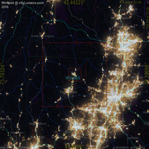
Analysis of Winsted night lights 2016
Square area 10x10 km:
 0.48%
0.48%90-99
1.59%80-89
1.11%70-79
2.54%60-69
2.06%50-59
1.43%40-49
0.63%30-39
1.43%20-29
3.33%10-19
2.54%0-9
82.86%Square area 50x50 km:
0.22%90-99
0.52%80-89
1.47%70-79
1.32%60-69
1.66%50-59
1.73%40-49
1.95%30-39
2.18%20-29
3.35%10-19
5.58%0-9
80%Clear (daylight) street map image can be seen on geolist.org.
Map coordinates:
42° 26' 32" North, 73° 45' 47.7" West
41° 55' 16.4" North, 73° 3' 36.4" West
41° 23' 45.2" North, 72° 21' 25.2" West
Some cities around Winsted sort by population:
• Bristol
29.2 km =18.1 mi,  161°
161°
• West Torrington
13.4 km =8.3 mi,  211°
211°
• Torrington
14.3 km =8.9 mi,  200°
200°
• Plymouth
27.7 km =17.2 mi,  178°
178°
• Winchester Center
6.6 km =4.1 mi,  249°
249°
• Southwick
28.2 km =17.5 mi,  58°
58°
• Simsbury Center
21.1 km =13.1 mi,  102°
102°
• Terryville
27.3 km =17 mi,  171°
171°
4845953 (p: 7,712)
Sources (retrieved 2019-11-25):
» Earth at Night: Flat Maps 2012, 2016