Southwick night lights from space
Night Light of Southwick (Massachusetts) from space (United States) Src. Average luminocity for 10x10km area is 17.5667% and for 50x50km: 26.9951%.
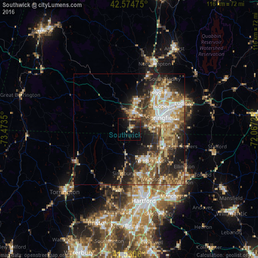
Analysis of Southwick night lights 2016
Square area 10x10 km:
 0%
0%90-99
1.11%80-89
3.17%70-79
2.06%60-69
2.06%50-59
1.75%40-49
2.38%30-39
4.92%20-29
11.75%10-19
17.3%0-9
53.49%Square area 50x50 km:
3.51%90-99
4.2%80-89
4.72%70-79
3.86%60-69
4.57%50-59
4.79%40-49
3.98%30-39
4.86%20-29
6.76%10-19
9.39%0-9
49.36%Clear (daylight) street map image can be seen on geolist.org.
Map coordinates:
42° 34' 29.1" North, 73° 28' 24.6" West
42° 3' 17.4" North, 72° 46' 13.3" West
41° 31' 50.2" North, 72° 4' 2.1" West
Some cities around Southwick sort by population:
• Springfield
15.8 km =9.8 mi,  70°
70°
• Chicopee
17 km =10.6 mi,  52°
52°
• Enfield
17.1 km =10.6 mi,  120°
120°
• Westfield
8 km =5 mi,  12°
12°
• Agawam
12.9 km =8 mi,  82°
82°
• West Springfield
13.7 km =8.5 mi,  64°
64°
• Longmeadow
15.5 km =9.6 mi,  91°
91°
• Thompsonville
15.5 km =9.6 mi,  114°
114°
4951640 (p: 9,444)
Sources (retrieved 2019-11-25):
» Earth at Night: Flat Maps 2012, 2016