Wilson night lights from space
Night Light of Wilson (Pennsylvania) from space (United States) Src. Average luminocity for 10x10km area is 68.0763% and for 50x50km: 22.2503%.
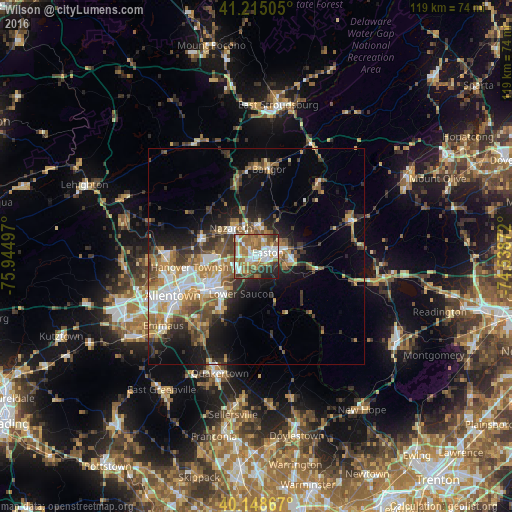
Analysis of Wilson night lights 2016
Square area 10x10 km:
 18.18%
90-99
13.15%80-89
3.08%70-79
10.71%60-69
17.69%50-59
14.12%40-49
4.55%30-39
8.12%20-29
8.93%10-19
1.46%0-9
0%Square area 50x50 km:
3.5%90-99
3.54%80-89
2.24%70-79
3.08%60-69
3.85%50-59
3.88%40-49
3.27%30-39
4.15%20-29
4.45%10-19
9.34%0-9
58.71%Clear (daylight) street map image can be seen on geolist.org.
Map coordinates:
41° 12' 54.2" North, 75° 56' 41.9" West
40° 41' 2.4" North, 75° 14' 30.6" West
40° 8' 55.2" North, 74° 32' 19.4" West
Some cities around Wilson sort by population:
• Bethlehem
12.6 km =7.8 mi,  239°
239°
• Easton
1.8 km =1.1 mi,  74°
74°
• Phillipsburg
4.5 km =2.8 mi,  76°
76°
• Middletown
8.8 km =5.5 mi, 239°
• Catasauqua
19.9 km =12.4 mi,  260°
260°
• Hellertown
14.3 km =8.9 mi,  215°
215°
• Nazareth
8.5 km =5.3 mi,  317°
317°
• Bangor
20.4 km =12.7 mi,  8°
8°
5219668 (p: 7,781)
Sources (retrieved 2019-11-25):
» Earth at Night: Flat Maps 2012, 2016