Bangor night lights from space
Night Light of Bangor (Pennsylvania) from space (United States) Src. Average luminocity for 10x10km area is 16.8418% and for 50x50km: 16.9703%.
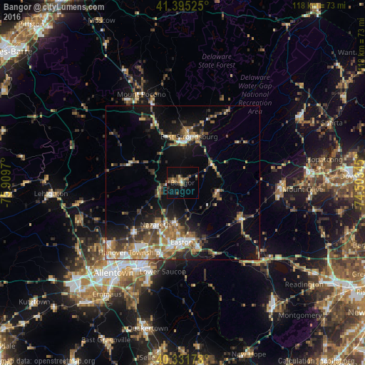
Analysis of Bangor night lights 2016
Square area 10x10 km:
 0.34%
0.34%90-99
0.68%80-89
3.06%70-79
3.23%60-69
1.19%50-59
4.42%40-49
3.23%30-39
2.55%20-29
3.74%10-19
9.35%0-9
68.2%Square area 50x50 km:
2.07%90-99
1.82%80-89
1.83%70-79
2.32%60-69
2.8%50-59
3.22%40-49
2.67%30-39
3.51%20-29
3.69%10-19
9.65%0-9
66.41%Clear (daylight) street map image can be seen on geolist.org.
Map coordinates:
41° 23' 42.9" North, 75° 54' 34.9" West
40° 51' 56.3" North, 75° 12' 23.7" West
40° 19' 54.4" North, 74° 30' 12.4" West
Some cities around Bangor sort by population:
• Easton
19.7 km =12.2 mi,  183°
183°
• Phillipsburg
19.2 km =11.9 mi, 175°
• East Stroudsburg
15 km =9.3 mi,  8°
8°
• Wilson
20.4 km =12.7 mi,  188°
188°
• Washington
22.5 km =14 mi,  121°
121°
• Arlington Heights
13.9 km =8.6 mi,  356°
356°
• Nazareth
16.4 km =10.2 mi,  211°
211°
• Stroudsburg
13.5 km =8.4 mi,  4°
4°
5178996 (p: 5,203)
Sources (retrieved 2019-11-25):
» Earth at Night: Flat Maps 2012, 2016