Williamsburg night lights from space
Night Light of Williamsburg (Florida) from space (United States) Src. Average luminocity for 10x10km area is 95.1627% and for 50x50km: 74.0572%.
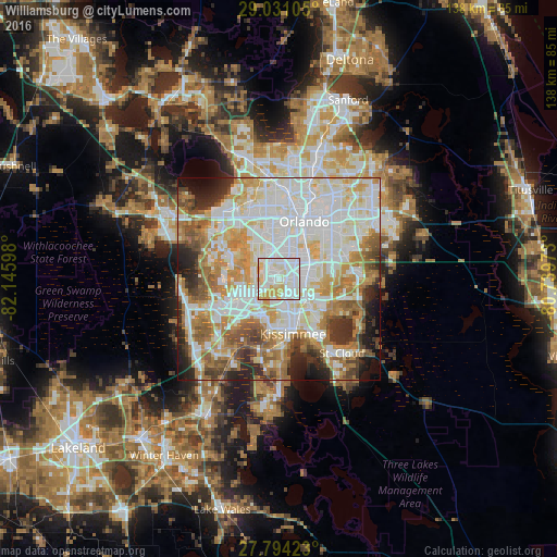
Analysis of Williamsburg night lights 2016
Square area 10x10 km:
 41.87%
90-99
34.92%80-89
17.26%70-79
5.95%60-69
0%50-59
0%40-49
0%30-39
0%20-29
0%10-19
0%0-9
0%Square area 50x50 km:
23.02%90-99
21.14%80-89
8.67%70-79
9.17%60-69
10.85%50-59
6.37%40-49
4.87%30-39
4.4%20-29
5.8%10-19
4.59%0-9
1.1%Clear (daylight) street map image can be seen on geolist.org.
Map coordinates:
29° 1' 51.8" North, 82° 8' 45.5" West
28° 24' 52" North, 81° 26' 34.3" West
27° 47' 39.2" North, 80° 44' 23" West
Some cities around Williamsburg sort by population:
• Meadow Woods
8.1 km =5 mi,  113°
113°
• Oak Ridge
6.6 km =4.1 mi,  15°
15°
• Southchase
6.3 km =3.9 mi, 112°
• Hunters Creek
6.3 km =3.9 mi,  161°
161°
• Doctor Phillips
6.2 km =3.9 mi,  308°
308°
• Pine Castle
9.7 km =6 mi,  48°
48°
• Belle Isle
9.5 km =5.9 mi,  59°
59°
• Sky Lake
6.9 km =4.3 mi, 46°
4178397 (p: 7,646)
Sources (retrieved 2019-11-25):
» Earth at Night: Flat Maps 2012, 2016