Hunters Creek night lights from space
Night Light of Hunters Creek (Florida) from space (United States) Src. Average luminocity for 10x10km area is 93.4008% and for 50x50km: 68.6371%.
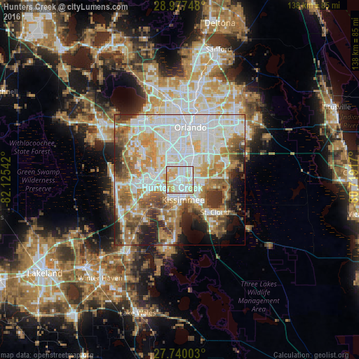
Analysis of Hunters Creek night lights 2016
Square area 10x10 km:
 34.13%
90-99
34.92%80-89
17.66%70-79
13.29%60-69
0%50-59
0%40-49
0%30-39
0%20-29
0%10-19
0%0-9
0%Square area 50x50 km:
20.81%90-99
18.12%80-89
7.22%70-79
8.59%60-69
11.71%50-59
6.83%40-49
5.31%30-39
4.8%20-29
5.68%10-19
5.31%0-9
5.62%Clear (daylight) street map image can be seen on geolist.org.
Map coordinates:
28° 58' 38.9" North, 82° 7' 31.5" West
28° 21' 38" North, 81° 25' 20.2" West
27° 44' 24.1" North, 80° 43' 9" West
Some cities around Hunters Creek sort by population:
• Kissimmee
6.2 km =3.9 mi,  174°
174°
• Buenaventura Lakes
7.3 km =4.5 mi,  112°
112°
• Meadow Woods
6.1 km =3.8 mi,  63°
63°
• Southchase
5.2 km =3.2 mi,  46°
46°
• Doctor Phillips
12 km =7.5 mi,  325°
325°
• Williamsburg
6.3 km =3.9 mi,  341°
341°
• Celebration
11.5 km =7.1 mi,  250°
250°
• Sky Lake
11.2 km =7 mi,  15°
15°
4159416 (p: 14,321)
Sources (retrieved 2019-11-25):
» Earth at Night: Flat Maps 2012, 2016