Whitmore Lake night lights from space
Night Light of Whitmore Lake (Michigan) from space (United States) Src. Average luminocity for 10x10km area is 21.527% and for 50x50km: 30.7744%.
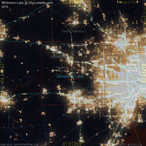
Analysis of Whitmore Lake night lights 2016
Square area 10x10 km:
 0%
0%90-99
1.9%80-89
1.27%70-79
3.33%60-69
2.06%50-59
3.49%40-49
5.08%30-39
3.33%20-29
8.41%10-19
40.16%0-9
30.95%Square area 50x50 km:
3.87%90-99
4.79%80-89
3.67%70-79
3.87%60-69
5.81%50-59
5.88%40-49
5.2%30-39
4.55%20-29
7.86%10-19
17.62%0-9
36.89%Clear (daylight) street map image can be seen on geolist.org.
Map coordinates:
42° 57' 23.2" North, 84° 26' 54.3" West
42° 26' 22.9" North, 83° 44' 43.1" West
41° 55' 7.1" North, 83° 2' 31.8" West
Some cities around Whitmore Lake sort by population:
• Ann Arbor
18 km =11.2 mi,  178°
178°
• Novi
22.6 km =14 mi,  78°
78°
• Wixom
19.6 km =12.2 mi,  61°
61°
• South Lyon
8 km =5 mi,  73°
73°
• Plymouth
23.8 km =14.8 mi,  108°
108°
• Brighton
10.4 km =6.5 mi,  343°
343°
• Milford
20.9 km =13 mi,  34°
34°
• Northville
21.5 km =13.4 mi,  92°
92°
5014946 (p: 6,423)
Sources (retrieved 2019-11-25):
» Earth at Night: Flat Maps 2012, 2016