Plymouth night lights from space
Night Light of Plymouth (Michigan) from space (United States) Src. Average luminocity for 10x10km area is 80.9111% and for 50x50km: 64.1564%.
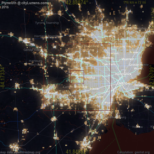
Analysis of Plymouth night lights 2016
Square area 10x10 km:
 18.1%
18.1%90-99
22.7%80-89
13.49%70-79
18.73%60-69
12.22%50-59
11.43%40-49
2.22%30-39
1.11%20-29
0%10-19
0%0-9
0%Square area 50x50 km:
17.19%90-99
17.06%80-89
7.36%70-79
7.82%60-69
10.33%50-59
8.21%40-49
5.36%30-39
3.83%20-29
7.62%10-19
9.92%0-9
5.32%Clear (daylight) street map image can be seen on geolist.org.
Map coordinates:
42° 53' 19.5" North, 84° 10' 24" West
42° 22' 17.1" North, 83° 28' 12.8" West
41° 50' 59.4" North, 82° 46' 1.5" West
Some cities around Plymouth sort by population:
• Livonia
9.7 km =6 mi,  92°
92°
• Canton
7 km =4.3 mi,  188°
188°
• Westland
7.8 km =4.8 mi,  132°
132°
• Novi
12.1 km =7.5 mi,  357°
357°
• Garden City
12.5 km =7.8 mi,  114°
114°
• Wayne
12.2 km =7.6 mi,  145°
145°
• Farmington
12.9 km =8 mi,  36°
36°
• Northville
6.7 km =4.2 mi,  350°
350°
5006059 (p: 8,905)
Sources (retrieved 2019-11-25):
» Earth at Night: Flat Maps 2012, 2016