Whitestown night lights from space
Night Light of Whitestown (Indiana) from space (United States) Src. Average luminocity for 10x10km area is 29.9184% and for 50x50km: 31.8486%.
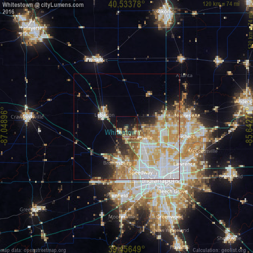
Analysis of Whitestown night lights 2016
Square area 10x10 km:
 2.55%
2.55%90-99
2.04%80-89
2.04%70-79
7.65%60-69
5.61%50-59
2.72%40-49
5.78%30-39
7.82%20-29
12.59%10-19
23.47%0-9
27.72%Square area 50x50 km:
8.04%90-99
7%80-89
5.16%70-79
5.95%60-69
3.76%50-59
3.08%40-49
2.09%30-39
2.31%20-29
3.18%10-19
6.69%0-9
52.75%Clear (daylight) street map image can be seen on geolist.org.
Map coordinates:
40° 32' 1.6" North, 87° 2' 56.3" West
39° 59' 50.1" North, 86° 20' 45" West
39° 27' 23.4" North, 85° 38' 33.8" West
Some cities around Whitestown sort by population:
• Carmel
19.5 km =12.1 mi,  96°
96°
• Westfield
19.3 km =12 mi,  74°
74°
• Zionsville
8.8 km =5.5 mi,  125°
125°
• Brownsburg
17.7 km =11 mi,  194°
194°
• Fairfield Heights
19 km =11.8 mi, 189°
• Broad Ripple
22.7 km =14.1 mi, 129°
• Lebanon
11.9 km =7.4 mi,  298°
298°
• Speedway
22.7 km =14.1 mi,  162°
162°
4266965 (p: 6,013)
Sources (retrieved 2019-11-25):
» Earth at Night: Flat Maps 2012, 2016