Speedway night lights from space
Night Light of Speedway (Indiana) from space (United States) Src. Average luminocity for 10x10km area is 93.1701% and for 50x50km: 60.3936%.
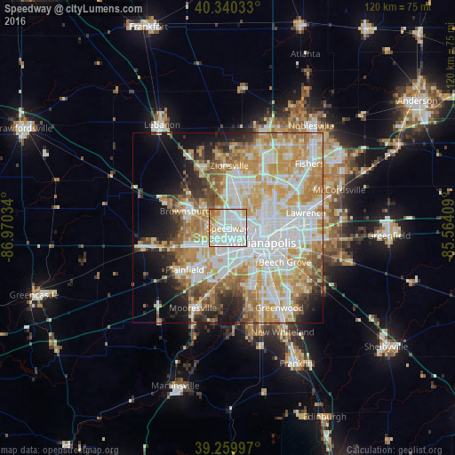
Analysis of Speedway night lights 2016
Square area 10x10 km:
 36.39%
90-99
36.9%80-89
13.95%70-79
7.65%60-69
4.59%50-59
0.51%40-49
0%30-39
0%20-29
0%10-19
0%0-9
0%Square area 50x50 km:
16.6%90-99
14.68%80-89
8.73%70-79
11.58%60-69
7.97%50-59
4.97%40-49
3.6%30-39
3.56%20-29
5.07%10-19
7.81%0-9
15.45%Clear (daylight) street map image can be seen on geolist.org.
Map coordinates:
40° 20' 25.2" North, 86° 58' 13.2" West
39° 48' 8.2" North, 86° 16' 2" West
39° 15' 35.9" North, 85° 33' 50.7" West
Some cities around Speedway sort by population:
• Indianapolis
10.1 km =6.3 mi,  111°
111°
• Plainfield
15.7 km =9.8 mi,  226°
226°
• Zionsville
16.5 km =10.3 mi,  1°
1°
• Brownsburg
12.1 km =7.5 mi,  292°
292°
• Fairfield Heights
10.3 km =6.4 mi, 286°
• Broad Ripple
12.9 km =8 mi,  56°
56°
• Avon
12.1 km =7.5 mi,  248°
248°
• Beech Grove
17.6 km =10.9 mi,  120°
120°
4265146 (p: 12,127)
Sources (retrieved 2019-11-25):
» Earth at Night: Flat Maps 2012, 2016