Wheat Ridge night lights from space
Night Light of Wheat Ridge (Colorado) from space (United States) Src. Average luminocity for 10x10km area is 94.5578% and for 50x50km: 58.9495%.

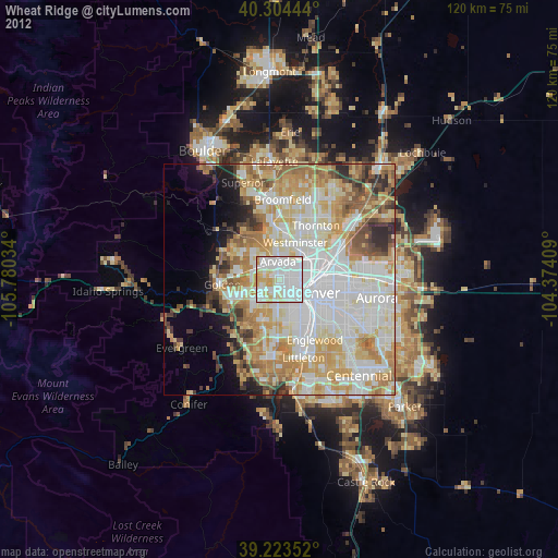
Analysis of Wheat Ridge night lights 2016
Square area 10x10 km:
 42.86%
90-99
33.5%80-89
13.95%70-79
9.69%60-69
0%50-59
0%40-49
0%30-39
0%20-29
0%10-19
0%0-9
0%Square area 50x50 km:
17.66%90-99
14.21%80-89
8.54%70-79
10.18%60-69
7.7%50-59
5.32%40-49
3.86%30-39
3.7%20-29
3.54%10-19
4.07%0-9
21.21%Clear (daylight) street map image can be seen on geolist.org.
Map coordinates:
40° 18' 16" North, 105° 46' 49.2" West
39° 45' 58" North, 105° 4' 38" West
39° 13' 24.7" North, 104° 22' 26.7" West
Some cities around Wheat Ridge sort by population:
• Denver
8.5 km =5.3 mi,  110°
110°
• Lakewood
6.8 km =4.2 mi,  182°
182°
• Arvada
4.2 km =2.6 mi,  347°
347°
• Westminster
8.6 km =5.3 mi,  23°
23°
• Berkley
6.1 km =3.8 mi,  45°
45°
• Applewood
7.3 km =4.5 mi,  262°
262°
• Twin Lakes
9 km =5.6 mi,  43°
43°
• Edgewater
1.8 km =1.1 mi,  142°
142°
5443948 (p: 31,192)
Sources (retrieved 2019-11-25):
» Earth at Night: Flat Maps 2012, 2016