Twin Lakes night lights from space
Night Light of Twin Lakes (Colorado) from space (United States) Src. Average luminocity for 10x10km area is 96.5204% and for 50x50km: 63.33%.
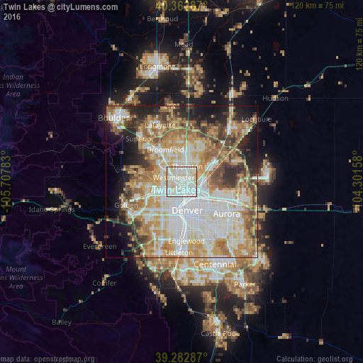
Analysis of Twin Lakes night lights 2016
Square area 10x10 km:
 46.09%
90-99
39.46%80-89
12.93%70-79
1.53%60-69
0%50-59
0%40-49
0%30-39
0%20-29
0%10-19
0%0-9
0%Square area 50x50 km:
17.28%90-99
14.16%80-89
9.25%70-79
11.03%60-69
8.36%50-59
6.62%40-49
5.87%30-39
5.01%20-29
6.71%10-19
7.34%0-9
8.38%Clear (daylight) street map image can be seen on geolist.org.
Map coordinates:
40° 21' 46.3" North, 105° 42' 28.2" West
39° 49' 30" North, 105° 0' 16.9" West
39° 16' 58.3" North, 104° 18' 5.7" West
Some cities around Twin Lakes sort by population:
• Thornton
5.5 km =3.4 mi,  30°
30°
• Westminster
3.1 km =1.9 mi,  295°
295°
• Commerce City
6.3 km =3.9 mi,  107°
107°
• Sherrelwood
1.4 km =0.9 mi,  11°
11°
• Welby
4.1 km =2.5 mi,  71°
71°
• Federal Heights
3 km =1.9 mi, 10°
• Berkley
2.9 km =1.8 mi,  218°
218°
• Shaw Heights
4.5 km =2.8 mi,  313°
313°
5442271 (p: 6,101)
Sources (retrieved 2019-11-25):
» Earth at Night: Flat Maps 2012, 2016