Applewood night lights from space
Night Light of Applewood (Colorado) from space (United States) Src. Average luminocity for 10x10km area is 78.5782% and for 50x50km: 47.8447%.
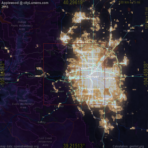
Analysis of Applewood night lights 2016
Square area 10x10 km:
 20.92%
90-99
19.73%80-89
11.22%70-79
13.61%60-69
14.97%50-59
10.88%40-49
4.93%30-39
3.23%20-29
0.51%10-19
0%0-9
0%Square area 50x50 km:
14.61%90-99
11.22%80-89
7.21%70-79
8.73%60-69
6.02%50-59
3.97%40-49
2.31%30-39
2.63%20-29
2.88%10-19
4.16%0-9
36.26%Clear (daylight) street map image can be seen on geolist.org.
Map coordinates:
40° 17' 46.3" North, 105° 51' 56.3" West
39° 45' 28" North, 105° 9' 45" West
39° 12' 54.5" North, 104° 27' 33.8" West
Some cities around Applewood sort by population:
• Lakewood
9.1 km =5.7 mi,  130°
130°
• Arvada
8.1 km =5 mi,  52°
52°
• Westminster
13.8 km =8.6 mi, 50°
• Wheat Ridge
7.3 km =4.5 mi,  82°
82°
• Golden
5 km =3.1 mi,  267°
267°
• Berkley
12.8 km =8 mi,  66°
66°
• Edgewater
8.4 km =5.2 mi,  93°
93°
• Shaw Heights
14.7 km =9.1 mi,  44°
44°
5412030 (p: 7,160)
Sources (retrieved 2019-11-25):
» Earth at Night: Flat Maps 2012, 2016