Westwood night lights from space
Night Light of Westwood (Massachusetts) from space (United States) Src. Average luminocity for 10x10km area is 53.303% and for 50x50km: 55.3243%.
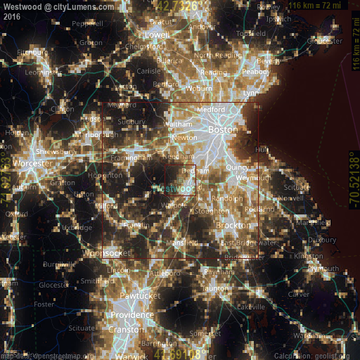
Analysis of Westwood night lights 2016
Square area 10x10 km:
 11.21%
90-99
13.33%80-89
2.73%70-79
3.18%60-69
10.61%50-59
8.79%40-49
9.24%30-39
5.61%20-29
17.27%10-19
17.73%0-9
0.3%Square area 50x50 km:
12.64%90-99
10.98%80-89
5.96%70-79
6.05%60-69
8.19%50-59
8.43%40-49
9.09%30-39
8.87%20-29
14.43%10-19
13.1%0-9
2.25%Clear (daylight) street map image can be seen on geolist.org.
Map coordinates:
42° 43' 57.4" North, 71° 55' 39.5" West
42° 12' 50.4" North, 71° 13' 28.2" West
41° 41' 27.9" North, 70° 31' 17" West
Some cities around Westwood sort by population:
• Needham
7.8 km =4.8 mi,  354°
354°
• Norwood
3 km =1.9 mi,  136°
136°
• Wellesley
10.7 km =6.6 mi,  328°
328°
• Dedham
5.7 km =3.5 mi,  57°
57°
• Canton
9 km =5.6 mi,  133°
133°
• Medfield
7.4 km =4.6 mi,  246°
246°
• Walpole
8.3 km =5.2 mi,  194°
194°
• Sharon
10.7 km =6.6 mi,  159°
159°
4955317 (p: 14,029)
Sources (retrieved 2019-11-25):
» Earth at Night: Flat Maps 2012, 2016