Westminster night lights from space
Night Light of Westminster (Maryland) from space (United States) Src. Average luminocity for 10x10km area is 41.2906% and for 50x50km: 16.82%.
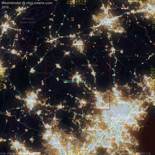
Analysis of Westminster night lights 2016
Square area 10x10 km:
 6.33%
6.33%90-99
6.66%80-89
6.66%70-79
3.73%60-69
5.36%50-59
8.28%40-49
0.65%30-39
9.42%20-29
13.15%10-19
34.58%0-9
5.19%Square area 50x50 km:
1.84%90-99
2.29%80-89
2.42%70-79
1.77%60-69
2.41%50-59
2.41%40-49
2.51%30-39
3.13%20-29
4.13%10-19
12.84%0-9
64.25%Clear (daylight) street map image can be seen on geolist.org.
Map coordinates:
40° 6' 54.8" North, 77° 41' 56.2" West
39° 34' 31.4" North, 76° 59' 44.9" West
39° 1' 52.7" North, 76° 17' 33.7" West
Some cities around Westminster sort by population:
• Owings Mills
25.3 km =15.7 mi,  133°
133°
• Eldersburg
19.5 km =12.1 mi,  168°
168°
• Reisterstown
18.3 km =11.4 mi, 129°
• Hanover
25.1 km =15.6 mi,  2°
2°
• Linganore
23.6 km =14.7 mi,  230°
230°
• Taneytown
17.8 km =11.1 mi,  300°
300°
• Parkville
23.1 km =14.4 mi,  6°
6°
• Hampstead
12.9 km =8 mi,  75°
75°
4373238 (p: 18,670)
Sources (retrieved 2019-11-25):
» Earth at Night: Flat Maps 2012, 2016