Parkville night lights from space
Night Light of Parkville (Pennsylvania) from space (United States) Src. Average luminocity for 10x10km area is 46.1378% and for 50x50km: 17.4815%.
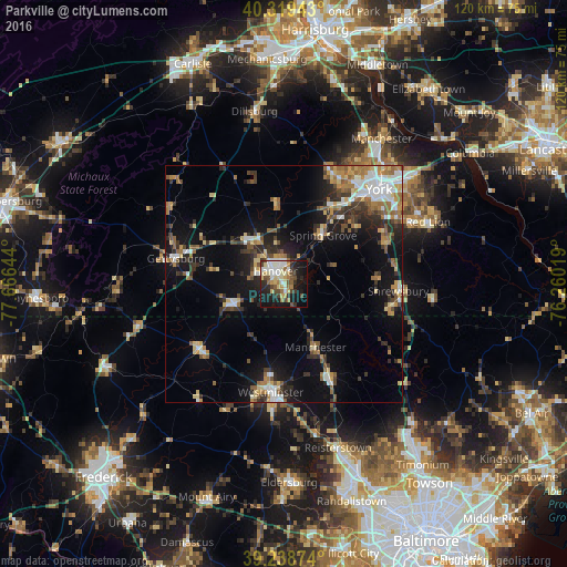
Analysis of Parkville night lights 2016
Square area 10x10 km:
 7.14%
7.14%90-99
10.71%80-89
8.67%70-79
4.08%60-69
6.8%50-59
3.06%40-49
7.99%30-39
5.61%20-29
9.86%10-19
28.57%0-9
7.48%Square area 50x50 km:
2.28%90-99
2.46%80-89
2.42%70-79
1.75%60-69
2.96%50-59
2.38%40-49
2.09%30-39
3.18%20-29
4.21%10-19
11%0-9
65.27%Clear (daylight) street map image can be seen on geolist.org.
Map coordinates:
40° 19' 9.9" North, 77° 39' 59.2" West
39° 46' 52.4" North, 76° 57' 47.9" West
39° 14' 19.5" North, 76° 15' 36.7" West
Some cities around Parkville sort by population:
• York
28.5 km =17.7 mi,  44°
44°
• Westminster
23.1 km =14.4 mi,  186°
186°
• Hanover
2.7 km =1.7 mi,  322°
322°
• Weigelstown
25.5 km =15.8 mi,  28°
28°
• Shiloh
26.1 km =16.2 mi, 32°
• Gettysburg
23.5 km =14.6 mi,  283°
283°
• Taneytown
22.7 km =14.1 mi,  232°
232°
• Hampstead
21.9 km =13.6 mi,  153°
153°
4560237 (p: 6,706)
Sources (retrieved 2019-11-25):
» Earth at Night: Flat Maps 2012, 2016