Hanover night lights from space
Night Light of Hanover (Pennsylvania) from space (United States) Src. Average luminocity for 10x10km area is 56.4694% and for 50x50km: 16.4865%.
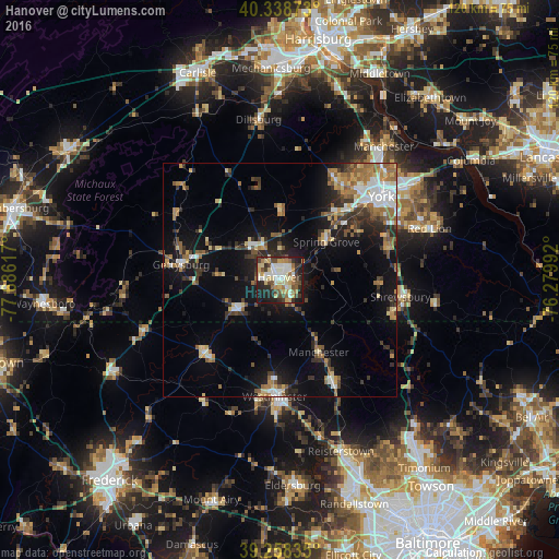
Analysis of Hanover night lights 2016
Square area 10x10 km:
 8.84%
8.84%90-99
12.41%80-89
11.9%70-79
7.48%60-69
7.99%50-59
3.91%40-49
9.35%30-39
8.5%20-29
14.63%10-19
14.97%0-9
0%Square area 50x50 km:
1.98%90-99
2.16%80-89
2.16%70-79
1.71%60-69
2.93%50-59
2.49%40-49
2.08%30-39
3.08%20-29
4.03%10-19
10.35%0-9
67.04%Clear (daylight) street map image can be seen on geolist.org.
Map coordinates:
40° 20' 19.4" North, 77° 41' 10.2" West
39° 48' 2.4" North, 76° 58' 58.9" West
39° 15' 30.1" North, 76° 16' 47.7" West
Some cities around Hanover sort by population:
• York
28.3 km =17.6 mi,  50°
50°
• Westminster
25.1 km =15.6 mi,  182°
182°
• Weigelstown
24.5 km =15.2 mi,  33°
33°
• Shiloh
25.3 km =15.7 mi,  38°
38°
• Gettysburg
21.5 km =13.4 mi,  279°
279°
• Taneytown
22.8 km =14.2 mi,  225°
225°
• Parkville
2.7 km =1.7 mi,  142°
142°
• Hampstead
24.6 km =15.3 mi,  152°
152°
4558475 (p: 15,496)
Sources (retrieved 2019-11-25):
» Earth at Night: Flat Maps 2012, 2016