Taneytown night lights from space
Night Light of Taneytown (Maryland) from space (United States) Src. Average luminocity for 10x10km area is 11.1737% and for 50x50km: 13.9362%.
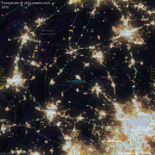
Analysis of Taneytown night lights 2016
Square area 10x10 km:
 0.49%
0.49%90-99
2.11%80-89
3.08%70-79
1.46%60-69
1.3%50-59
1.62%40-49
0.32%30-39
0%20-29
0%10-19
1.14%0-9
88.47%Square area 50x50 km:
1.38%90-99
1.69%80-89
2.1%70-79
1.51%60-69
1.59%50-59
1.71%40-49
1.69%30-39
2.78%20-29
3.94%10-19
11.51%0-9
70.11%Clear (daylight) street map image can be seen on geolist.org.
Map coordinates:
40° 11' 49.5" North, 77° 52' 39.2" West
39° 39' 28.4" North, 77° 10' 27.9" West
39° 6' 52" North, 76° 28' 16.7" West
Some cities around Taneytown sort by population:
• Westminster
17.8 km =11.1 mi,  120°
120°
• Hanover
22.8 km =14.2 mi,  45°
45°
• Linganore
24.4 km =15.2 mi,  186°
186°
• Gettysburg
19.8 km =12.3 mi,  345°
345°
• Parkville
22.7 km =14.1 mi, 52°
• Thurmont
20.6 km =12.8 mi,  259°
259°
• Hampstead
28.4 km =17.6 mi,  101°
101°
• Walkersville
24.4 km =15.2 mi,  218°
218°
4370931 (p: 6,746)
Sources (retrieved 2019-11-25):
» Earth at Night: Flat Maps 2012, 2016