West Vero Corridor night lights from space
Night Light of West Vero Corridor (Florida) from space (United States) Src. Average luminocity for 10x10km area is 46.3492% and for 50x50km: 16.2349%.
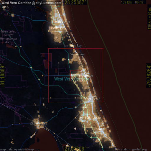
Analysis of West Vero Corridor night lights 2016
Square area 10x10 km:
 2.38%
2.38%90-99
4.17%80-89
2.58%70-79
7.94%60-69
18.06%50-59
15.08%40-49
7.14%30-39
7.54%20-29
15.67%10-19
15.87%0-9
3.57%Square area 50x50 km:
1.36%90-99
1.75%80-89
0.87%70-79
1.46%60-69
6.34%50-59
3.49%40-49
2.88%30-39
2.83%20-29
5.15%10-19
8.33%0-9
65.53%Clear (daylight) street map image can be seen on geolist.org.
Map coordinates:
28° 15' 31.9" North, 81° 11' 20" West
27° 38' 15.9" North, 80° 29' 8.7" West
27° 0' 47.1" North, 79° 46' 57.5" West
Some cities around West Vero Corridor sort by population:
• Sebastian
19.9 km =12.4 mi,  4°
4°
• Vero Beach South
7.5 km =4.7 mi,  108°
108°
• Florida Ridge
11.7 km =7.3 mi,  123°
123°
• Vero Beach
8.7 km =5.4 mi,  89°
89°
• Lakewood Park
13.4 km =8.3 mi,  141°
141°
• Gifford
8.6 km =5.3 mi,  61°
61°
• Fort Pierce North
22.1 km =13.7 mi,  145°
145°
• Fellsmere
18.4 km =11.4 mi,  321°
321°
4177950 (p: 7,138)
Sources (retrieved 2019-11-25):
» Earth at Night: Flat Maps 2012, 2016