Fellsmere night lights from space
Night Light of Fellsmere (Florida) from space (United States) Src. Average luminocity for 10x10km area is 8.0754% and for 50x50km: 13.6954%.
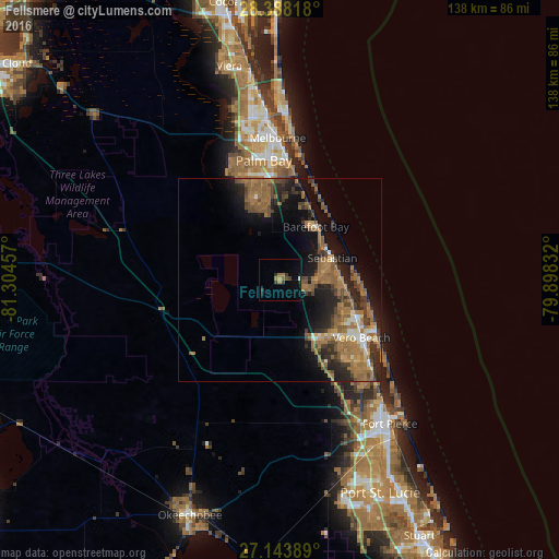
Analysis of Fellsmere night lights 2016
Square area 10x10 km:
 0.4%
0.4%90-99
0%80-89
0%70-79
0.79%60-69
2.78%50-59
1.19%40-49
1.39%30-39
2.58%20-29
1.98%10-19
2.18%0-9
86.71%Square area 50x50 km:
0.65%90-99
0.97%80-89
0.64%70-79
1.16%60-69
6.08%50-59
3.61%40-49
2.62%30-39
2.47%20-29
3.95%10-19
8%0-9
69.85%Clear (daylight) street map image can be seen on geolist.org.
Map coordinates:
28° 23' 17.4" North, 81° 18' 16.5" West
27° 46' 4.1" North, 80° 36' 5.2" West
27° 8' 38" North, 79° 53' 54" West
Some cities around Fellsmere sort by population:
• Palm Bay
29.7 km =18.5 mi,  2°
2°
• Sebastian
14 km =8.7 mi,  67°
67°
• Vero Beach South
25 km =15.5 mi,  132°
132°
• Florida Ridge
29.7 km =18.5 mi, 134°
• Vero Beach
24.7 km =15.3 mi, 125°
• Gifford
21.5 km =13.4 mi,  118°
118°
• Micco
16 km =9.9 mi,  38°
38°
• West Vero Corridor
18.4 km =11.4 mi,  141°
141°
4154972 (p: 5,514)
Sources (retrieved 2019-11-25):
» Earth at Night: Flat Maps 2012, 2016