Wellington night lights from space
Night Light of Wellington (Kansas) from space (United States) Src. Average luminocity for 10x10km area is 20.5272% and for 50x50km: 1.9184%.
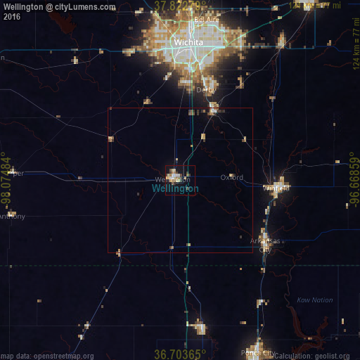
Analysis of Wellington night lights 2016
Square area 10x10 km:
 2.38%
2.38%90-99
1.87%80-89
4.59%70-79
2.21%60-69
4.42%50-59
1.7%40-49
1.87%30-39
4.76%20-29
0.68%10-19
15.82%0-9
59.69%Square area 50x50 km:
0.13%90-99
0.13%80-89
0.39%70-79
0.24%60-69
0.3%50-59
0.28%40-49
0.24%30-39
0.49%20-29
0.23%10-19
0.88%0-9
96.69%Clear (daylight) street map image can be seen on geolist.org.
Map coordinates:
37° 49' 22" North, 98° 4' 29.4" West
37° 15' 55.1" North, 97° 22' 18.2" West
36° 42' 13.1" North, 96° 40' 6.9" West
Some cities around Wellington sort by population:
• Wichita
47.6 km =29.6 mi,  3°
3°
• Derby
32.5 km =20.2 mi,  16°
16°
• Andover
54 km =33.6 mi, 22°
• Winfield
33.4 km =20.8 mi,  94°
94°
• Arkansas City
37.2 km =23.1 mi,  127°
127°
• Haysville
33.3 km =20.7 mi, 2°
• Blackwell
51.8 km =32.2 mi,  171°
171°
• Mulvane
25.9 km =16.1 mi,  25°
25°
4281386 (p: 7,987)
Sources (retrieved 2019-11-25):
» Earth at Night: Flat Maps 2012, 2016