Mulvane night lights from space
Night Light of Mulvane (Kansas) from space (United States) Src. Average luminocity for 10x10km area is 15.8539% and for 50x50km: 16.8801%.
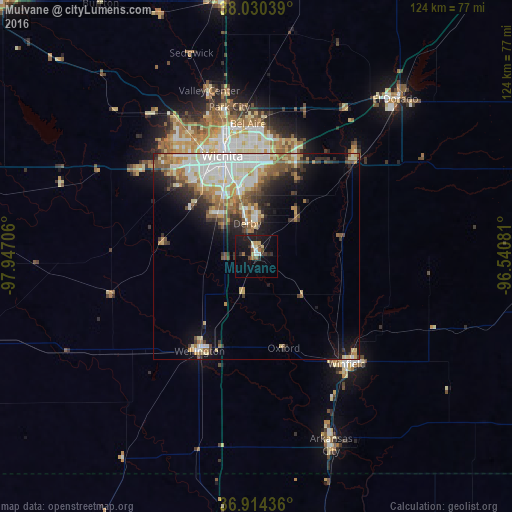
Analysis of Mulvane night lights 2016
Square area 10x10 km:
 1.14%
1.14%90-99
1.62%80-89
2.76%70-79
0.97%60-69
1.79%50-59
1.95%40-49
1.46%30-39
2.6%20-29
3.41%10-19
22.08%0-9
60.23%Square area 50x50 km:
3.6%90-99
3.47%80-89
2.34%70-79
1.9%60-69
2.25%50-59
2.45%40-49
1.53%30-39
2.36%20-29
2.83%10-19
5.93%0-9
71.34%Clear (daylight) street map image can be seen on geolist.org.
Map coordinates:
38° 1' 49.4" North, 97° 56' 49.4" West
37° 28' 28.1" North, 97° 14' 38.1" West
36° 54' 51.7" North, 96° 32' 26.9" West
Some cities around Mulvane sort by population:
• Wichita
25.6 km =15.9 mi,  341°
341°
• Derby
8.2 km =5.1 mi, 344°
• Andover
28.3 km =17.6 mi,  19°
19°
• Winfield
34.1 km =21.2 mi,  139°
139°
• Haysville
13.8 km =8.6 mi,  316°
316°
• Augusta
33.3 km =20.7 mi,  44°
44°
• Wellington
25.9 km =16.1 mi,  205°
205°
• Park City
36.8 km =22.9 mi,  349°
349°
4276017 (p: 6,314)
Sources (retrieved 2019-11-25):
» Earth at Night: Flat Maps 2012, 2016