Waunakee night lights from space
Night Light of Waunakee (Wisconsin) from space (United States) Src. Average luminocity for 10x10km area is 21.4455% and for 50x50km: 18.279%.
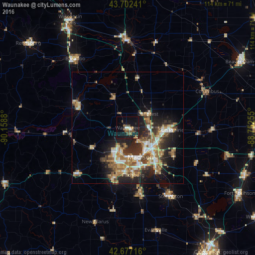
Analysis of Waunakee night lights 2016
Square area 10x10 km:
 1.36%
1.36%90-99
2.12%80-89
1.36%70-79
2.88%60-69
2.42%50-59
4.24%40-49
6.06%30-39
1.67%20-29
4.55%10-19
33.33%0-9
40%Square area 50x50 km:
2.33%90-99
2.52%80-89
2.72%70-79
2.57%60-69
2.87%50-59
3.16%40-49
2.6%30-39
2.77%20-29
5.82%10-19
8.83%0-9
63.82%Clear (daylight) street map image can be seen on geolist.org.
Map coordinates:
43° 42' 8.7" North, 90° 9' 31.7" West
43° 11' 31" North, 89° 27' 20.4" West
42° 40' 37.8" North, 88° 45' 9.2" West
Some cities around Waunakee sort by population:
• Madison
13.9 km =8.6 mi,  161°
161°
• Sun Prairie
19.6 km =12.2 mi,  92°
92°
• Middleton
11.2 km =7 mi,  200°
200°
• Verona
23.2 km =14.4 mi, 195°
• De Forest
11 km =6.8 mi,  55°
55°
• McFarland
24.1 km =15 mi,  145°
145°
• Monona
17.5 km =10.9 mi, 145°
• Cottage Grove
24.4 km =15.2 mi,  121°
121°
5278073 (p: 13,311)
Sources (retrieved 2019-11-25):
» Earth at Night: Flat Maps 2012, 2016